Andosilla geodata
Andosilla (Navarre) is a seat of a third-order administrative division; located in Spain in Europe/Madrid (GMT+2) time zone. In our database, there are 6762 cities with bigger population. Compared to other cities in Spain, 84.1% of cities are located further ↓South; 68.1% of cities are located further ←West and 74% of cities have higher elevation than Andosilla. Note1


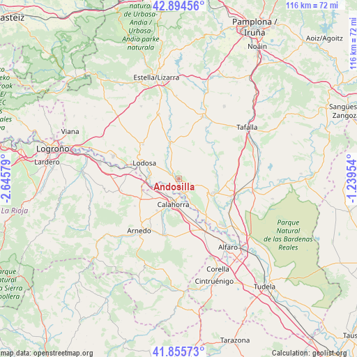
Andosilla GPS coordinates[2]
42° 22' 38.244" North, 1° 56' 33.612" West
| Map corner | latitude | longitude |
|---|---|---|
| Upper-left | 42.89456°, | -2.64579° |
| Center: | 42.37729°, | -1.94267° |
| Lower-right: | 41.85573°, | -1.23954° |
| Map W x H: | 115.5×115.5 km | = 71.8×71.8mi |
| max Lat: | 43.74134° ⇑15.9% North |
| Andosilla: | 42.37729° |
| min Lat: | ⇓84.1% South 27.64134° |
| min Long | Andosilla | max Long |
| -18.00367° | -1.94267° | 4.2899° |
| W 68.1%⇐ | ⇒31.9% E |
Elevation
Elevation of Andosilla is 316 m = 1037 ft, and this is 282 m = 925 ft below average elevation for this country.
| Max E: |
1682 m = 5518 ft | 74% |
| Avg. | 598 m = 1962 ft | |
| Andosilla | 316 m = 1037 ft | |
Min E: |
0 m = 0 ft | 26% |
See also: Spain elevation on elevation.city.
Geographical zone
Andosilla is located in North temperate zone (between Tropic of Cancer and the Arctic Circle). Distance of this Northern Tropic circle is 2106 km =1308.6 mi to South.| Distance of | km | miles | from Andosilla |
|---|---|---|---|
| North Pole | 5295.1 | 3290.2 | to North |
| Arctic Circle | 2689.3 | 1671.1 | to North |
| Tropic Cancer | 2106 | 1308.6 | to South |
| Equator | 4711.9 | 2927.8 | to South |


Nearby cities:
15 places around Andosilla: (largest is in red/bold)
• Alcanadre
14.9 km =9.3 mi,  281°
281°
• Azagra
9.3 km =5.8 mi,  157°
157°
• Calahorra
8.2 km =5.1 mi,  192°
192°
• Cárcar
3.5 km =2.2 mi,  300°
300°
• El Villar de Arnedo
14 km =8.7 mi,  243°
243°
• Falces
12.4 km =7.7 mi,  83°
83°
• Funes
13.6 km =8.5 mi,  120°
120°
• Lerín
12 km =7.5 mi,  348°
348°
• Lodosa
12.2 km =7.6 mi,  294°
294°
• Miranda de Arga
15.1 km =9.4 mi,  38°
38°
• Peralta
12.5 km =7.8 mi,  110°
110°
• Pradejón
11.4 km =7.1 mi,  245°
245°
• San Adrián
4.8 km =3 mi,  172°
172°
• Sartaguda
9.4 km =5.8 mi,  274°
274°
• Sesma
16.1 km =10 mi,  313°
313°
Sources, notices
• [Note1] Compared only with cities in Spain existing in our database
• [Src1] Map data: © OpenStreetMap contributors (CC-BY-SA)
• [Src2] Other city data from geonames.org with taken over terms of usage.
• [Src3] Geographical zone / Annual Mean Temperature by Robert A. Rohde @ Wikipedia
