Gallipienzo geodata
Gallipienzo (Navarre) is a seat of a third-order administrative division; located in Spain in Europe/Madrid (GMT+2) time zone. With population of 155 people, there are 5384 cities with bigger population in this country. Compared to other cities in Spain, 87.8% of cities are located further ↓South; 73.8% of cities are located further ←West and 58.2% of cities have higher elevation than Gallipienzo. Note1
Administrative division(s):
- Level 1: Navarre
- Level 2: Provincia de Navarra
- Level 3: Gallipienzo/Galipentzu


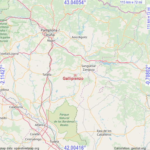
Gallipienzo GPS coordinates[2]
42° 31' 28.2" North, 1° 24' 40.14" West
| Map corner | latitude | longitude |
|---|---|---|
| Upper-left | 43.04054°, | -2.11427° |
| Center: | 42.5245°, | -1.41115° |
| Lower-right: | 42.00416°, | -0.70802° |
| Map W x H: | 115.2×115.2 km | = 71.6×71.6mi |
| max Lat: | 43.74134° ⇑12.2% North |
| Gallipienzo: | 42.5245° |
| min Lat: | ⇓87.8% South 27.64134° |
| min Long | Gallipienzo | max Long |
| -18.00367° | -1.41115° | 4.2899° |
| W 73.8%⇐ | ⇒26.2% E |
Elevation
Elevation of Gallipienzo is 550 m = 1804 ft, and this is 48 m = 157 ft below average elevation for this country.
| Max E: |
1682 m = 5518 ft | 58.2% |
| Avg. | 598 m = 1962 ft | |
| Gallipienzo | 550 m = 1804 ft | |
Min E: |
0 m = 0 ft | 41.8% |
See also: Spain elevation on elevation.city.
Geographical zone
Gallipienzo is located in North temperate zone (between Tropic of Cancer and the Arctic Circle). Distance of this Northern Tropic circle is 2122.4 km =1318.8 mi to South.| Distance of | km | miles | from Gallipienzo |
|---|---|---|---|
| North Pole | 5278.8 | 3280.1 | to North |
| Arctic Circle | 2672.9 | 1660.9 | to North |
| Tropic Cancer | 2122.4 | 1318.8 | to South |
| Equator | 4728.3 | 2938 | to South |


Nearby cities:
15 places around Gallipienzo: (largest is in red/bold)
• Carcastillo
16.4 km =10.2 mi,  189°
189°
• Cáseda
3.7 km =2.3 mi,  93°
93°
• Eslava
6 km =3.7 mi,  318°
318°
• Javier
18.2 km =11.3 mi,  65°
65°
• Leache
9.2 km =5.7 mi,  1°
1°
• Lerga
8.8 km =5.5 mi,  303°
303°
• Liédena
15.3 km =9.5 mi,  46°
46°
• Lumbier
16.7 km =10.4 mi,  30°
30°
• Murillo el Fruto
15.2 km =9.4 mi,  195°
195°
• Orísoain
18 km =11.2 mi, 298°
• San Martín de Unx
12.3 km =7.6 mi,  270°
270°
• Sangüesa/Zangoza
11.9 km =7.4 mi,  61°
61°
• Sos del Rey Católico
16.4 km =10.2 mi,  100°
100°
• Ujué
7.8 km =4.8 mi,  249°
249°
• Áibar
8.6 km =5.3 mi, 28°
Sources, notices
• [Note1] Compared only with cities in Spain existing in our database
• [Src1] Map data: © OpenStreetMap contributors (CC-BY-SA)
• [Src2] Other city data from geonames.org with taken over terms of usage.
• [Src3] Geographical zone / Annual Mean Temperature by Robert A. Rohde @ Wikipedia
