Castigaleu geodata
Castigaleu (Aragon) is a seat of a third-order administrative division; located in Spain in Europe/Madrid (GMT+2) time zone. With population of 117 people, there are 5732 cities with bigger population in this country. Compared to other cities in Spain, 79.3% of cities are located further ↓South; 89.3% of cities are located further ←West and 73% of cities have lower elevation than Castigaleu. Note1


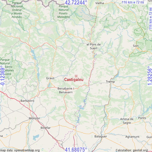
Castigaleu GPS coordinates[2]
42° 12' 13.464" North, 0° 34' 45.984" East
| Map corner | latitude | longitude |
|---|---|---|
| Upper-left | 42.72244°, | -0.12369° |
| Center: | 42.20374°, | 0.57944° |
| Lower-right: | 41.68075°, | 1.28256° |
| Map W x H: | 115.8×115.8 km | = 72×72mi |
| max Lat: | 43.74134° ⇑20.7% North |
| Castigaleu: | 42.20374° |
| min Lat: | ⇓79.3% South 27.64134° |
| min Long | Castigaleu | max Long |
| -18.00367° | 0.57944° | 4.2899° |
| W 89.3%⇐ | ⇒10.7% E |
Elevation
Elevation of Castigaleu is 835 m = 2740 ft, and this is 237 m = 778 ft above average elevation for this country.
| Max E: |
1682 m = 5518 ft | 27% |
| Castigaleu | 835 m 2740 ft | |
| Avg. | 598 m = 1962 ft | |
Min E: |
0 m = 0 ft | 73% |
See also: Spain elevation on elevation.city.
Geographical zone
Castigaleu is located in North temperate zone (between Tropic of Cancer and the Arctic Circle). Distance of this Northern Tropic circle is 2086.7 km =1296.6 mi to South.| Distance of | km | miles | from Castigaleu |
|---|---|---|---|
| North Pole | 5314.4 | 3302.2 | to North |
| Arctic Circle | 2708.6 | 1683 | to North |
| Tropic Cancer | 2086.7 | 1296.6 | to South |
| Equator | 4692.6 | 2915.8 | to South |


Nearby cities:
15 places around Castigaleu: (largest is in red/bold)
• Areny de Noguera / Arén
13.2 km =8.2 mi,  62°
62°
• Baells
29.6 km =18.4 mi,  199°
199°
• Benavarri / Benabarre
13.5 km =8.4 mi,  216°
216°
• Beranuy
18.1 km =11.2 mi,  3°
3°
• Bonansa
25.8 km =16 mi,  16°
16°
• Campo
27.4 km =17 mi,  326°
326°
• Camporrells
27.7 km =17.2 mi,  189°
189°
• Capella
15.1 km =9.4 mi,  266°
266°
• Graus
20 km =12.4 mi, 265°
• Lascuarre
5 km =3.1 mi,  260°
260°
• Laspaúles
29.8 km =18.5 mi, 2°
• Secastilla
25.8 km =16 mi, 264°
• Sopeira
18.6 km =11.6 mi,  47°
47°
• Tremp
26.3 km =16.3 mi,  98°
98°
• Àger
27.4 km =17 mi,  145°
145°
Sources, notices
• [Note1] Compared only with cities in Spain existing in our database
• [Src1] Map data: © OpenStreetMap contributors (CC-BY-SA)
• [Src2] Other city data from geonames.org with taken over terms of usage.
• [Src3] Geographical zone / Annual Mean Temperature by Robert A. Rohde @ Wikipedia
