Lascuarre geodata
Lascuarre (Aragon) is a seat of a third-order administrative division; located in Spain in Europe/Madrid (GMT+2) time zone. With population of 143 people, there are 5475 cities with bigger population in this country. Compared to other cities in Spain, 79.1% of cities are located further ↓South; 89.1% of cities are located further ←West and 50.5% of cities have higher elevation than Lascuarre. Note1


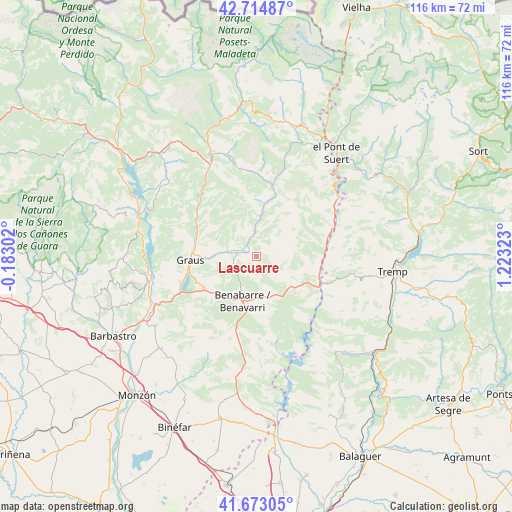
Lascuarre GPS coordinates[2]
42° 11' 45.996" North, 0° 31' 12.36" East
| Map corner | latitude | longitude |
|---|---|---|
| Upper-left | 42.71487°, | -0.18302° |
| Center: | 42.19611°, | 0.5201° |
| Lower-right: | 41.67305°, | 1.22323° |
| Map W x H: | 115.8×115.8 km | = 72×72mi |
| max Lat: | 43.74134° ⇑20.9% North |
| Lascuarre: | 42.19611° |
| min Lat: | ⇓79.1% South 27.64134° |
| min Long | Lascuarre | max Long |
| -18.00367° | 0.5201° | 4.2899° |
| W 89.1%⇐ | ⇒10.9% E |
Elevation
Elevation of Lascuarre is 652 m = 2139 ft, and this is 54 m = 177 ft above average elevation for this country.
| Max E: |
1682 m = 5518 ft | 50.5% |
| Lascuarre | 652 m 2139 ft | |
| Avg. | 598 m = 1962 ft | |
Min E: |
0 m = 0 ft | 49.5% |
See also: Spain elevation on elevation.city.
Geographical zone
Lascuarre is located in North temperate zone (between Tropic of Cancer and the Arctic Circle). Distance of this Northern Tropic circle is 2085.8 km =1296.1 mi to South.| Distance of | km | miles | from Lascuarre |
|---|---|---|---|
| North Pole | 5315.3 | 3302.8 | to North |
| Arctic Circle | 2709.4 | 1683.5 | to North |
| Tropic Cancer | 2085.8 | 1296.1 | to South |
| Equator | 4691.8 | 2915.3 | to South |


Nearby cities:
15 places around Lascuarre: (largest is in red/bold)
• Abizanda
27.1 km =16.8 mi,  280°
280°
• Areny de Noguera / Arén
18 km =11.2 mi,  67°
67°
• Baells
27.5 km =17.1 mi,  190°
190°
• Benavarri / Benabarre
10.5 km =6.5 mi,  197°
197°
• Beranuy
19.9 km =12.4 mi,  17°
17°
• Campo
25.8 km =16 mi,  336°
336°
• Camporrells
26.4 km =16.4 mi,  179°
179°
• Capella
10.2 km =6.3 mi,  270°
270°
• Castigaleu
5 km =3.1 mi,  80°
80°
• El Grado
25 km =15.5 mi,  258°
258°
• Estada
27.5 km =17.1 mi,  239°
239°
• Graus
15.1 km =9.4 mi, 266°
• Palo
26.7 km =16.6 mi,  301°
301°
• Secastilla
20.9 km =13 mi, 265°
• Sopeira
22.9 km =14.2 mi,  54°
54°
Sources, notices
• [Note1] Compared only with cities in Spain existing in our database
• [Src1] Map data: © OpenStreetMap contributors (CC-BY-SA)
• [Src2] Other city data from geonames.org with taken over terms of usage.
• [Src3] Geographical zone / Annual Mean Temperature by Robert A. Rohde @ Wikipedia
