Castelserás geodata
Castelserás (Aragon) is a seat of a third-order administrative division; located in Spain in Europe/Madrid (GMT+2) time zone. With population of 808 people, there are 3192 cities with bigger population in this country. Compared to other cities in Spain, 52% of cities are located further ↑North; 86.1% of cities are located further ←West and 70.7% of cities have higher elevation than Castelserás. Note1


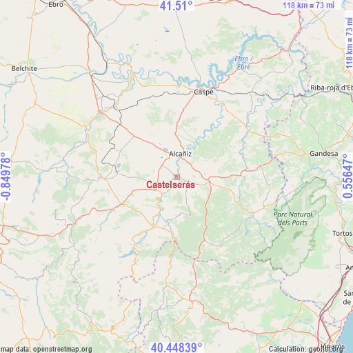
Castelserás GPS coordinates[2]
40° 58' 52.788" North, 0° 8' 47.976" West
| Map corner | latitude | longitude |
|---|---|---|
| Upper-left | 41.51°, | -0.84978° |
| Center: | 40.98133°, | -0.14666° |
| Lower-right: | 40.44839°, | 0.55647° |
| Map W x H: | 118×118 km | = 73.3×73.3mi |
| max Lat: | 43.74134° ⇑52% North |
| Castelserás: | 40.98133° |
| min Lat: | ⇓48% South 27.64134° |
| min Long | Castelserás | max Long |
| -18.00367° | -0.14666° | 4.2899° |
| W 86.1%⇐ | ⇒13.9% E |
Elevation
Elevation of Castelserás is 370 m = 1214 ft, and this is 228 m = 748 ft below average elevation for this country.
| Max E: |
1682 m = 5518 ft | 70.7% |
| Avg. | 598 m = 1962 ft | |
| Castelserás | 370 m = 1214 ft | |
Min E: |
0 m = 0 ft | 29.3% |
See also: Spain elevation on elevation.city.
Geographical zone
Castelserás is located in North temperate zone (between Tropic of Cancer and the Arctic Circle). Distance of this Northern Tropic circle is 1950.8 km =1212.2 mi to South.| Distance of | km | miles | from Castelserás |
|---|---|---|---|
| North Pole | 5450.4 | 3386.7 | to North |
| Arctic Circle | 2844.5 | 1767.5 | to North |
| Tropic Cancer | 1950.8 | 1212.2 | to South |
| Equator | 4556.7 | 2831.4 | to South |


Nearby cities:
15 places around Castelserás: (largest is in red/bold)
• Aguaviva
18.2 km =11.3 mi,  193°
193°
• Alcañiz
7.7 km =4.8 mi,  8°
8°
• Alcorisa
22.1 km =13.7 mi,  243°
243°
• Calanda
8.5 km =5.3 mi, 238°
• Foz-Calanda
11.9 km =7.4 mi, 236°
• Fórnoles
15.5 km =9.6 mi,  129°
129°
• La Ginebrosa
12.4 km =7.7 mi,  175°
175°
• Mas de las Matas
18.3 km =11.4 mi,  206°
206°
• Ráfales
21.2 km =13.2 mi,  138°
138°
• Torre del Compte
22.1 km =13.7 mi,  103°
103°
• Torrecilla de Alcañiz
5.2 km =3.2 mi,  116°
116°
• Torrevelilla
9.3 km =5.8 mi,  160°
160°
• Valdealgorfa
9.5 km =5.9 mi,  83°
83°
• Valdeltormo
19.3 km =12 mi,  88°
88°
• Valjunquera
14.8 km =9.2 mi, 102°
Sources, notices
• [Note1] Compared only with cities in Spain existing in our database
• [Src1] Map data: © OpenStreetMap contributors (CC-BY-SA)
• [Src2] Other city data from geonames.org with taken over terms of usage.
• [Src3] Geographical zone / Annual Mean Temperature by Robert A. Rohde @ Wikipedia
