Ujué geodata
Ujué (Navarre) is a seat of a third-order administrative division; located in Spain in Europe/Madrid (GMT+2) time zone. With population of 239 people, there are 4812 cities with bigger population in this country. Compared to other cities in Spain, 87.2% of cities are located further ↓South; 72.9% of cities are located further ←West and 51.9% of cities have higher elevation than Ujué. Note1


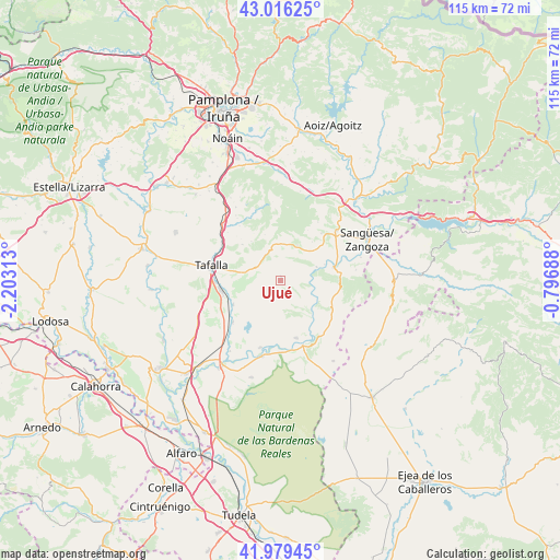
Ujué GPS coordinates[2]
42° 30' 0" North, 1° 30' 0" West
| Map corner | latitude | longitude |
|---|---|---|
| Upper-left | 43.01625°, | -2.20313° |
| Center: | 42.5°, | -1.5° |
| Lower-right: | 41.97945°, | -0.79688° |
| Map W x H: | 115.3×115.3 km | = 71.6×71.6mi |
| max Lat: | 43.74134° ⇑12.8% North |
| Ujué: | 42.5° |
| min Lat: | ⇓87.2% South 27.64134° |
| min Long | Ujué | max Long |
| -18.00367° | -1.5° | 4.2899° |
| W 72.9%⇐ | ⇒27.1% E |
Elevation
Elevation of Ujué is 638 m = 2093 ft, and this is 40 m = 131 ft above average elevation for this country.
| Max E: |
1682 m = 5518 ft | 51.9% |
| Ujué | 638 m 2093 ft | |
| Avg. | 598 m = 1962 ft | |
Min E: |
0 m = 0 ft | 48.1% |
See also: Spain elevation on elevation.city.
Geographical zone
Ujué is located in North temperate zone (between Tropic of Cancer and the Arctic Circle). Distance of this Northern Tropic circle is 2119.6 km =1317.1 mi to South.| Distance of | km | miles | from Ujué |
|---|---|---|---|
| North Pole | 5281.5 | 3281.8 | to North |
| Arctic Circle | 2675.6 | 1662.5 | to North |
| Tropic Cancer | 2119.6 | 1317.1 | to South |
| Equator | 4725.6 | 2936.4 | to South |


Nearby cities:
15 places around Ujué: (largest is in red/bold)
• Beire
11.2 km =7 mi,  242°
242°
• Carcastillo
14.2 km =8.8 mi,  161°
161°
• Cáseda
11.2 km =7 mi,  77°
77°
• Eslava
7.9 km =4.9 mi,  24°
24°
• Gallipienzo
7.8 km =4.8 mi,  69°
69°
• Leache
14.1 km =8.8 mi,  32°
32°
• Lerga
7.5 km =4.7 mi,  359°
359°
• Murillo el Fruto
12.4 km =7.7 mi, 164°
• Olite
12.7 km =7.9 mi,  259°
259°
• Orísoain
14.1 km =8.8 mi,  322°
322°
• Pitillas
13.2 km =8.2 mi,  228°
228°
• Pueyo
14.1 km =8.8 mi,  300°
300°
• San Martín de Unx
5.7 km =3.5 mi, 298°
• Tafalla
14.6 km =9.1 mi,  281°
281°
• Áibar
15.3 km =9.5 mi,  48°
48°
Sources, notices
• [Note1] Compared only with cities in Spain existing in our database
• [Src1] Map data: © OpenStreetMap contributors (CC-BY-SA)
• [Src2] Other city data from geonames.org with taken over terms of usage.
• [Src3] Geographical zone / Annual Mean Temperature by Robert A. Rohde @ Wikipedia
