Rucandio geodata
Rucandio (Castille and León) is a seat of a third-order administrative division; located in Spain in Europe/Madrid (GMT+2) time zone. With population of 76 people, there are 6179 cities with bigger population in this country. Compared to other cities in Spain, 92.1% of cities are located further ↓South; 52.9% of cities are located further →East and 68% of cities have lower elevation than Rucandio. Note1
Administrative division(s):
- Level 1: Castille and León
- Level 2: Provincia de Burgos
- Level 3: Rucandio


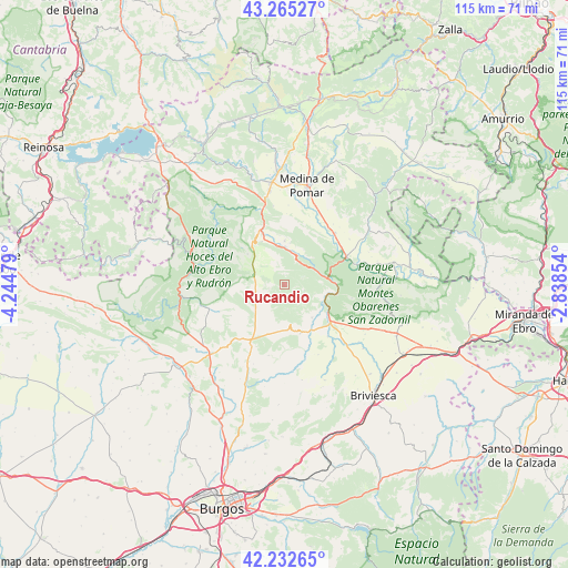
Rucandio GPS coordinates[2]
42° 45' 3.996" North, 3° 32' 29.976" West
| Map corner | latitude | longitude |
|---|---|---|
| Upper-left | 43.26527°, | -4.24479° |
| Center: | 42.75111°, | -3.54166° |
| Lower-right: | 42.23265°, | -2.83854° |
| Map W x H: | 114.8×114.8 km | = 71.3×71.3mi |
| max Lat: | 43.74134° ⇑7.9% North |
| Rucandio: | 42.75111° |
| min Lat: | ⇓92.1% South 27.64134° |
| min Long | Rucandio | max Long |
| -18.00367° | -3.54166° | 4.2899° |
| W 47.1%⇐ | ⇒52.9% E |
Elevation
Elevation of Rucandio is 799 m = 2621 ft, and this is 201 m = 659 ft above average elevation for this country.
| Max E: |
1682 m = 5518 ft | 32% |
| Rucandio | 799 m 2621 ft | |
| Avg. | 598 m = 1962 ft | |
Min E: |
0 m = 0 ft | 68% |
See also: Spain elevation on elevation.city.
Geographical zone
Rucandio is located in North temperate zone (between Tropic of Cancer and the Arctic Circle). Distance of this Northern Tropic circle is 2147.6 km =1334.5 mi to South.| Distance of | km | miles | from Rucandio |
|---|---|---|---|
| North Pole | 5253.6 | 3264.4 | to North |
| Arctic Circle | 2647.7 | 1645.2 | to North |
| Tropic Cancer | 2147.6 | 1334.5 | to South |
| Equator | 4753.5 | 2953.7 | to South |


Nearby cities:
15 places around Rucandio: (largest is in red/bold)
• Abajas
14.6 km =9.1 mi,  192°
192°
• Cantabrana
6.4 km =4 mi,  107°
107°
• Carcedo de Bureba
19.6 km =12.2 mi,  169°
169°
• Frías
20.3 km =12.6 mi,  86°
86°
• Llano de Bureba
15.6 km =9.7 mi,  154°
154°
• Medina de Pomar
20.3 km =12.6 mi,  12°
12°
• Navas de Bureba
19.2 km =11.9 mi, 113°
• Oña
10.5 km =6.5 mi,  100°
100°
• Padrones de Bureba
5.1 km =3.2 mi, 171°
• Piérnigas
20.7 km =12.9 mi, 149°
• Poza de la Sal
10.1 km =6.3 mi,  160°
160°
• Rojas
20.9 km =13 mi, 157°
• Salas de Bureba
8.6 km =5.3 mi,  139°
139°
• Sedano
17.4 km =10.8 mi,  257°
257°
• Trespaderne
13.6 km =8.5 mi,  65°
65°
Sources, notices
• [Note1] Compared only with cities in Spain existing in our database
• [Src1] Map data: © OpenStreetMap contributors (CC-BY-SA)
• [Src2] Other city data from geonames.org with taken over terms of usage.
• [Src3] Geographical zone / Annual Mean Temperature by Robert A. Rohde @ Wikipedia
