Fuentes Claras geodata
Fuentes Claras (Aragon) is a seat of a third-order administrative division; located in Spain in Europe/Madrid (GMT+2) time zone. With population of 554 people, there are 3728 cities with bigger population in this country. Compared to other cities in Spain, 54.7% of cities are located further ↑North; 74.6% of cities are located further ←West and 81.6% of cities have lower elevation than Fuentes Claras. Note1


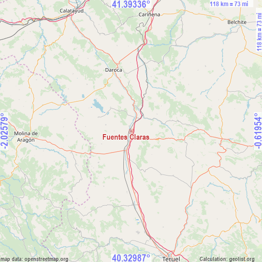
Fuentes Claras GPS coordinates[2]
40° 51' 49.5" North, 1° 19' 21.576" West
| Map corner | latitude | longitude |
|---|---|---|
| Upper-left | 41.39336°, | -2.02579° |
| Center: | 40.86375°, | -1.32266° |
| Lower-right: | 40.32987°, | -0.61954° |
| Map W x H: | 118.2×118.2 km | = 73.4×73.4mi |
| max Lat: | 43.74134° ⇑54.7% North |
| Fuentes Claras: | 40.86375° |
| min Lat: | ⇓45.3% South 27.64134° |
| min Long | Fuentes Claras | max Long |
| -18.00367° | -1.32266° | 4.2899° |
| W 74.6%⇐ | ⇒25.4% E |
Elevation
Elevation of Fuentes Claras is 913 m = 2995 ft, and this is 315 m = 1033 ft above average elevation for this country.
| Max E: |
1682 m = 5518 ft | 18.4% |
| Fuentes Claras | 913 m 2995 ft | |
| Avg. | 598 m = 1962 ft | |
Min E: |
0 m = 0 ft | 81.6% |
See also: Spain elevation on elevation.city.
Geographical zone
Fuentes Claras is located in North temperate zone (between Tropic of Cancer and the Arctic Circle). Distance of this Northern Tropic circle is 1937.7 km =1204 mi to South.| Distance of | km | miles | from Fuentes Claras |
|---|---|---|---|
| North Pole | 5463.4 | 3394.8 | to North |
| Arctic Circle | 2857.6 | 1775.6 | to North |
| Tropic Cancer | 1937.7 | 1204 | to South |
| Equator | 4543.6 | 2823.3 | to South |


Nearby cities:
15 places around Fuentes Claras: (largest is in red/bold)
• Barrachina
15.9 km =9.9 mi,  76°
76°
• Bañón
11.4 km =7.1 mi,  104°
104°
• Bello
16.2 km =10.1 mi,  293°
293°
• Blancas
14.5 km =9 mi,  247°
247°
• Bueña
17.8 km =11.1 mi,  164°
164°
• Burbáguena
17.2 km =10.7 mi,  355°
355°
• Calamocha
6.5 km =4 mi,  18°
18°
• Caminreal
2.8 km =1.7 mi,  182°
182°
• Castejón de Tornos
17.3 km =10.7 mi,  329°
329°
• Cosa
16 km =9.9 mi, 101°
• Monreal del Campo
8.9 km =5.5 mi,  198°
198°
• Rubielos de la Cérida
13.9 km =8.6 mi,  138°
138°
• Tornos
14.4 km =8.9 mi,  319°
319°
• Torralba de los Sisones
11.8 km =7.3 mi,  284°
284°
• Torrijo del Campo
4.4 km =2.7 mi, 196°
Sources, notices
• [Note1] Compared only with cities in Spain existing in our database
• [Src1] Map data: © OpenStreetMap contributors (CC-BY-SA)
• [Src2] Other city data from geonames.org with taken over terms of usage.
• [Src3] Geographical zone / Annual Mean Temperature by Robert A. Rohde @ Wikipedia
