Cabezón geodata
Cabezón (Castille and León) is a populated place; located in Spain in Europe/Madrid (GMT+2) time zone. With population of 2,540 people, there are 1890 cities with bigger population in this country. Compared to other cities in Spain, 66.9% of cities are located further ↓South; 67.9% of cities are located further →East and 54.8% of cities have lower elevation than Cabezón. Note1
Administrative division(s):
- Level 1: Castille and León
- Level 2: Provincia de Valladolid
- Level 3: Valladolid


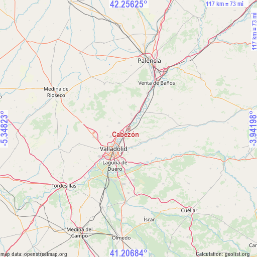
Cabezón GPS coordinates[2]
41° 44' 1.284" North, 4° 38' 42.36" West
| Map corner | latitude | longitude |
|---|---|---|
| Upper-left | 42.25625°, | -5.34823° |
| Center: | 41.73369°, | -4.6451° |
| Lower-right: | 41.20684°, | -3.94198° |
| Map W x H: | 116.7×116.7 km | = 72.5×72.5mi |
| max Lat: | 43.74134° ⇑33.1% North |
| Cabezón: | 41.73369° |
| min Lat: | ⇓66.9% South 27.64134° |
| min Long | Cabezón | max Long |
| -18.00367° | -4.6451° | 4.2899° |
| W 32.1%⇐ | ⇒67.9% E |
Elevation
Elevation of Cabezón is 708 m = 2323 ft, and this is 110 m = 361 ft above average elevation for this country.
| Max E: |
1682 m = 5518 ft | 45.2% |
| Cabezón | 708 m 2323 ft | |
| Avg. | 598 m = 1962 ft | |
Min E: |
0 m = 0 ft | 54.8% |
See also: Spain elevation on elevation.city.
Geographical zone
Cabezón is located in North temperate zone (between Tropic of Cancer and the Arctic Circle). Distance of this Northern Tropic circle is 2034.4 km =1264.1 mi to South.| Distance of | km | miles | from Cabezón |
|---|---|---|---|
| North Pole | 5366.7 | 3334.7 | to North |
| Arctic Circle | 2760.8 | 1715.5 | to North |
| Tropic Cancer | 2034.4 | 1264.1 | to South |
| Equator | 4640.4 | 2883.4 | to South |


Nearby cities:
15 places around Cabezón: (largest is in red/bold)
• Castronuevo de Esgueva
7.4 km =4.6 mi,  140°
140°
• Cigales
5.2 km =3.2 mi,  301°
301°
• Cistérniga
13.9 km =8.6 mi,  194°
194°
• Corcos
9.3 km =5.8 mi,  334°
334°
• Cubillas de Santa Marta
11.4 km =7.1 mi,  12°
12°
• Fuensaldaña
10.4 km =6.5 mi,  252°
252°
• Mucientes
9.7 km =6 mi,  275°
275°
• Olmos de Esgueva
11.4 km =7.1 mi,  116°
116°
• Quintanilla de Trigueros
13.5 km =8.4 mi,  354°
354°
• San Martín de Valvení
6.8 km =4.2 mi,  71°
71°
• Santovenia de Pisuerga
5.7 km =3.5 mi,  220°
220°
• Trigueros del Valle
10.8 km =6.7 mi,  357°
357°
• Valladolid
10.9 km =6.8 mi, 216°
• Valoria la Buena
12 km =7.5 mi,  52°
52°
• Villarmentero de Esgueva
9.8 km =6.1 mi, 123°
Sources, notices
• [Note1] Compared only with cities in Spain existing in our database
• [Src1] Map data: © OpenStreetMap contributors (CC-BY-SA)
• [Src2] Other city data from geonames.org with taken over terms of usage.
• [Src3] Geographical zone / Annual Mean Temperature by Robert A. Rohde @ Wikipedia
