Santovenia de Pisuerga geodata
Santovenia de Pisuerga (Castille and León) is a seat of a third-order administrative division; located in Spain in Europe/Madrid (GMT+2) time zone. With population of 2,691 people, there are 1823 cities with bigger population in this country. Compared to other cities in Spain, 65.9% of cities are located further ↓South; 68.5% of cities are located further →East and 53.5% of cities have lower elevation than Santovenia de Pisuerga. Note1
Administrative division(s):
- Level 1: Castille and León
- Level 2: Provincia de Valladolid
- Level 3: Santovenia de Pisuerga
Current local time in Santovenia de Pisuerga:
11:59 PM, ThursdayDifference from your time zone: hours


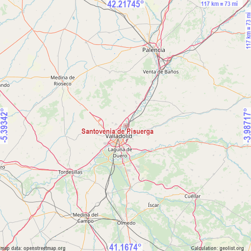
Santovenia de Pisuerga GPS coordinates[2]
41° 41' 40.452" North, 4° 41' 25.044" West
| Map corner | latitude | longitude |
|---|---|---|
| Upper-left | 42.21745°, | -5.39342° |
| Center: | 41.69457°, | -4.69029° |
| Lower-right: | 41.1674°, | -3.98717° |
| Map W x H: | 116.8×116.8 km | = 72.6×72.6mi |
| max Lat: | 43.74134° ⇑34.1% North |
| Santovenia de Pisuerga: | 41.69457° |
| min Lat: | ⇓65.9% South 27.64134° |
| min Long | Santovenia de P | max Long |
| -18.00367° | -4.69029° | 4.2899° |
| W 31.5%⇐ | ⇒68.5% E |
Elevation
Elevation of Santovenia de Pisuerga is 696 m = 2283 ft, and this is 98 m = 322 ft above average elevation for this country.
| Max E: |
1682 m = 5518 ft | 46.5% |
| Santovenia de Pisuerga | 696 m 2283 ft | |
| Avg. | 598 m = 1962 ft | |
Min E: |
0 m = 0 ft | 53.5% |
See also: Spain elevation on elevation.city.
Geographical zone
Santovenia de Pisuerga is located in North temperate zone (between Tropic of Cancer and the Arctic Circle). Distance of this Northern Tropic circle is 2030.1 km =1261.4 mi to South.| Distance of | km | miles | from Santovenia de Pisuerga |
|---|---|---|---|
| North Pole | 5371.1 | 3337.4 | to North |
| Arctic Circle | 2765.2 | 1718.2 | to North |
| Tropic Cancer | 2030.1 | 1261.4 | to South |
| Equator | 4636 | 2880.7 | to South |


Nearby cities:
15 places around Santovenia de Pisuerga: (largest is in red/bold)
• Arroyo de la Encomienda
13 km =8.1 mi,  223°
223°
• Cabezón
5.7 km =3.5 mi,  40°
40°
• Castronuevo de Esgueva
8.6 km =5.3 mi,  99°
99°
• Cigales
7.1 km =4.4 mi,  354°
354°
• Cistérniga
9.1 km =5.7 mi,  178°
178°
• Corcos
12.8 km =8 mi,  359°
359°
• Fuensaldaña
6.4 km =4 mi,  281°
281°
• Laguna de Duero
12.9 km =8 mi,  192°
192°
• Mucientes
8 km =5 mi,  312°
312°
• Olmos de Esgueva
13.9 km =8.6 mi,  92°
92°
• San Martín de Valvení
12.1 km =7.5 mi,  57°
57°
• Valladolid
5.2 km =3.2 mi,  212°
212°
• Villanubla
12.6 km =7.8 mi,  272°
272°
• Villarmentero de Esgueva
12 km =7.5 mi, 95°
• Zaratán
8.7 km =5.4 mi,  243°
243°
Sources, notices
• [Note1] Compared only with cities in Spain existing in our database
• [Src1] Map data: © OpenStreetMap contributors (CC-BY-SA)
• [Src2] Other city data from geonames.org with taken over terms of usage.
• [Src3] Geographical zone / Annual Mean Temperature by Robert A. Rohde @ Wikipedia
