Mucientes geodata
Mucientes (Castille and León) is a seat of a third-order administrative division; located in Spain in Europe/Madrid (GMT+2) time zone. With population of 639 people, there are 3524 cities with bigger population in this country. Compared to other cities in Spain, 67.1% of cities are located further ↓South; 69.2% of cities are located further →East and 61.6% of cities have lower elevation than Mucientes. Note1
Administrative division(s):
- Level 1: Castille and León
- Level 2: Provincia de Valladolid
- Level 3: Mucientes


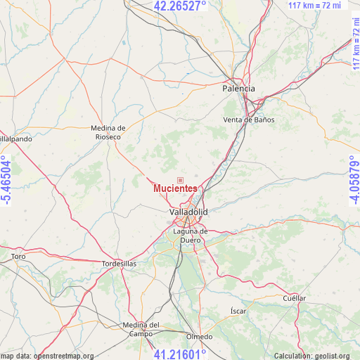
Mucientes GPS coordinates[2]
41° 44' 34.008" North, 4° 45' 42.876" West
| Map corner | latitude | longitude |
|---|---|---|
| Upper-left | 42.26527°, | -5.46504° |
| Center: | 41.74278°, | -4.76191° |
| Lower-right: | 41.21601°, | -4.05879° |
| Map W x H: | 116.7×116.7 km | = 72.5×72.5mi |
| max Lat: | 43.74134° ⇑32.9% North |
| Mucientes: | 41.74278° |
| min Lat: | ⇓67.1% South 27.64134° |
| min Long | Mucientes | max Long |
| -18.00367° | -4.76191° | 4.2899° |
| W 30.8%⇐ | ⇒69.2% E |
Elevation
Elevation of Mucientes is 755 m = 2477 ft, and this is 157 m = 515 ft above average elevation for this country.
| Max E: |
1682 m = 5518 ft | 38.4% |
| Mucientes | 755 m 2477 ft | |
| Avg. | 598 m = 1962 ft | |
Min E: |
0 m = 0 ft | 61.6% |
See also: Spain elevation on elevation.city.
Geographical zone
Mucientes is located in North temperate zone (between Tropic of Cancer and the Arctic Circle). Distance of this Northern Tropic circle is 2035.4 km =1264.7 mi to South.| Distance of | km | miles | from Mucientes |
|---|---|---|---|
| North Pole | 5365.7 | 3334.1 | to North |
| Arctic Circle | 2759.8 | 1714.9 | to North |
| Tropic Cancer | 2035.4 | 1264.7 | to South |
| Equator | 4641.4 | 2884 | to South |


Nearby cities:
15 places around Mucientes: (largest is in red/bold)
• Arroyo de la Encomienda
15.1 km =9.4 mi,  191°
191°
• Cabezón
9.7 km =6 mi,  95°
95°
• Cigales
5.5 km =3.4 mi,  72°
72°
• Ciguñuela
13.8 km =8.6 mi,  214°
214°
• Cistérniga
15.7 km =9.8 mi,  156°
156°
• Corcos
9.4 km =5.8 mi,  37°
37°
• Fuensaldaña
4.1 km =2.5 mi,  184°
184°
• Quintanilla de Trigueros
15.1 km =9.4 mi,  34°
34°
• Santovenia de Pisuerga
8 km =5 mi,  132°
132°
• Trigueros del Valle
13.4 km =8.3 mi, 43°
• Valladolid
10.2 km =6.3 mi, 161°
• Villalba de los Alcores
15.7 km =9.8 mi,  328°
328°
• Villanubla
8.2 km =5.1 mi,  233°
233°
• Wamba
14.9 km =9.3 mi,  239°
239°
• Zaratán
9.4 km =5.8 mi, 191°
Sources, notices
• [Note1] Compared only with cities in Spain existing in our database
• [Src1] Map data: © OpenStreetMap contributors (CC-BY-SA)
• [Src2] Other city data from geonames.org with taken over terms of usage.
• [Src3] Geographical zone / Annual Mean Temperature by Robert A. Rohde @ Wikipedia
