Fabero geodata
Fabero (Castille and León) is a seat of a third-order administrative division; located in Spain in Europe/Madrid (GMT+2) time zone. With population of 5,150 people, there are 1274 cities with bigger population in this country. Compared to other cities in Spain, 92.3% of cities are located further ↓South; 92.2% of cities are located further →East and 53.9% of cities have lower elevation than Fabero. Note1


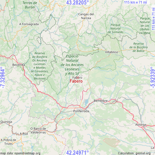
Fabero GPS coordinates[2]
42° 46' 4.908" North, 6° 37' 35.436" West
| Map corner | latitude | longitude |
|---|---|---|
| Upper-left | 43.28205°, | -7.32964° |
| Center: | 42.76803°, | -6.62651° |
| Lower-right: | 42.24971°, | -5.92339° |
| Map W x H: | 114.8×114.8 km | = 71.3×71.3mi |
| max Lat: | 43.74134° ⇑7.7% North |
| Fabero: | 42.76803° |
| min Lat: | ⇓92.3% South 27.64134° |
| min Long | Fabero | max Long |
| -18.00367° | -6.62651° | 4.2899° |
| W 7.8%⇐ | ⇒92.2% E |
Elevation
Elevation of Fabero is 700 m = 2297 ft, and this is 102 m = 335 ft above average elevation for this country.
| Max E: |
1682 m = 5518 ft | 46.1% |
| Fabero | 700 m 2297 ft | |
| Avg. | 598 m = 1962 ft | |
Min E: |
0 m = 0 ft | 53.9% |
See also: Spain elevation on elevation.city.
Geographical zone
Fabero is located in North temperate zone (between Tropic of Cancer and the Arctic Circle). Distance of this Northern Tropic circle is 2149.4 km =1335.6 mi to South.| Distance of | km | miles | from Fabero |
|---|---|---|---|
| North Pole | 5251.7 | 3263.3 | to North |
| Arctic Circle | 2645.8 | 1644 | to North |
| Tropic Cancer | 2149.4 | 1335.6 | to South |
| Equator | 4755.4 | 2954.9 | to South |


Nearby cities:
15 places around Fabero: (largest is in red/bold)
• Arganza
15 km =9.3 mi,  199°
199°
• Berlanga del Bierzo
4.5 km =2.8 mi,  157°
157°
• Cacabelos
20.3 km =12.6 mi, 203°
• Camponaraya
21.4 km =13.3 mi,  188°
188°
• Candín
9.9 km =6.2 mi,  303°
303°
• Cerredo
22.8 km =14.2 mi,  29°
29°
• Congosto
18.8 km =11.7 mi,  152°
152°
• Cubillos del Sil
16.7 km =10.4 mi, 162°
• Degaña
19.6 km =12.2 mi,  13°
13°
• Palacios del Sil
19.9 km =12.4 mi,  52°
52°
• Peranzanes
12.2 km =7.6 mi,  357°
357°
• Páramo del Sil
12.8 km =8 mi,  62°
62°
• Sancedo
11.3 km =7 mi,  183°
183°
• Toreno
12 km =7.5 mi,  129°
129°
• Vega de Espinareda
5.3 km =3.3 mi,  205°
205°
Sources, notices
• [Note1] Compared only with cities in Spain existing in our database
• [Src1] Map data: © OpenStreetMap contributors (CC-BY-SA)
• [Src2] Other city data from geonames.org with taken over terms of usage.
• [Src3] Geographical zone / Annual Mean Temperature by Robert A. Rohde @ Wikipedia
