Carballedo geodata
Carballedo (Galicia) is a seat of a third-order administrative division; located in Spain in Europe/Madrid (GMT+2) time zone. In our database, there are 6762 cities with bigger population. Compared to other cities in Spain, 87.7% of cities are located further ↓South; 96% of cities are located further →East and 56.4% of cities have higher elevation than Carballedo. Note1


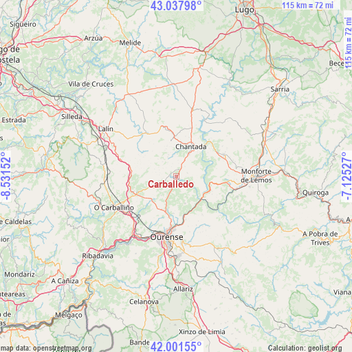
Carballedo GPS coordinates[2]
42° 31' 18.876" North, 7° 49' 42.24" West
| Map corner | latitude | longitude |
|---|---|---|
| Upper-left | 43.03798°, | -8.53152° |
| Center: | 42.52191°, | -7.8284° |
| Lower-right: | 42.00155°, | -7.12527° |
| Map W x H: | 115.2×115.2 km | = 71.6×71.6mi |
| max Lat: | 43.74134° ⇑12.3% North |
| Carballedo: | 42.52191° |
| min Lat: | ⇓87.7% South 27.64134° |
| min Long | Carballedo | max Long |
| -18.00367° | -7.8284° | 4.2899° |
| W 4%⇐ | ⇒96% E |
Elevation
Elevation of Carballedo is 575 m = 1886 ft, and this is 23 m = 75 ft below average elevation for this country.
| Max E: |
1682 m = 5518 ft | 56.4% |
| Avg. | 598 m = 1962 ft | |
| Carballedo | 575 m = 1886 ft | |
Min E: |
0 m = 0 ft | 43.6% |
See also: Spain elevation on elevation.city.
Geographical zone
Carballedo is located in North temperate zone (between Tropic of Cancer and the Arctic Circle). Distance of this Northern Tropic circle is 2122.1 km =1318.6 mi to South.| Distance of | km | miles | from Carballedo |
|---|---|---|---|
| North Pole | 5279.1 | 3280.3 | to North |
| Arctic Circle | 2673.2 | 1661 | to North |
| Tropic Cancer | 2122.1 | 1318.6 | to South |
| Equator | 4728 | 2937.8 | to South |


Nearby cities:
15 places around Carballedo: (largest is in red/bold)
• Amoeiro
15.4 km =9.6 mi,  220°
220°
• Cea
14 km =8.7 mi,  248°
248°
• Chantada
10.7 km =6.6 mi,  25°
25°
• Coles
13.6 km =8.5 mi,  181°
181°
• Dozón
16.9 km =10.5 mi,  293°
293°
• Luintra
15 km =9.3 mi,  146°
146°
• Maside
20.4 km =12.7 mi,  232°
232°
• Nogueira de Ramuín
13.3 km =8.3 mi, 151°
• Pantón
18.7 km =11.6 mi,  91°
91°
• Pereiro de Aguiar
19.8 km =12.3 mi,  173°
173°
• Piñor
14.4 km =8.9 mi,  260°
260°
• Rodeiro
17.8 km =11.1 mi,  324°
324°
• Taboada
19.7 km =12.2 mi,  1°
1°
• Vilamarín
8.2 km =5.1 mi, 219°
• Vilarnaz
13.8 km =8.6 mi,  191°
191°
Sources, notices
• [Note1] Compared only with cities in Spain existing in our database
• [Src1] Map data: © OpenStreetMap contributors (CC-BY-SA)
• [Src2] Other city data from geonames.org with taken over terms of usage.
• [Src3] Geographical zone / Annual Mean Temperature by Robert A. Rohde @ Wikipedia
