Sayatón geodata
Sayatón (Castille-La Mancha) is a seat of a third-order administrative division; located in Spain in Europe/Madrid (GMT+2) time zone. With population of 131 people, there are 5570 cities with bigger population in this country. Compared to other cities in Spain, 64.4% of cities are located further ↑North; 56.7% of cities are located further ←West and 50.2% of cities have lower elevation than Sayatón. Note1
Administrative division(s):
- Level 1: Castille-La Mancha
- Level 2: Provincia de Guadalajara
- Level 3: Sayatón


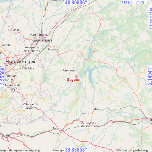
Sayatón GPS coordinates[2]
40° 22' 34.86" North, 2° 51' 9.108" West
| Map corner | latitude | longitude |
|---|---|---|
| Upper-left | 40.90986°, | -3.55566° |
| Center: | 40.37635°, | -2.85253° |
| Lower-right: | 39.83858°, | -2.14941° |
| Map W x H: | 119.1×119.1 km | = 74×74mi |
| max Lat: | 43.74134° ⇑64.4% North |
| Sayatón: | 40.37635° |
| min Lat: | ⇓35.6% South 27.64134° |
| min Long | Sayatón | max Long |
| -18.00367° | -2.85253° | 4.2899° |
| W 56.7%⇐ | ⇒43.3% E |
Elevation
Elevation of Sayatón is 661 m = 2169 ft, and this is 63 m = 207 ft above average elevation for this country.
| Max E: |
1682 m = 5518 ft | 49.8% |
| Sayatón | 661 m 2169 ft | |
| Avg. | 598 m = 1962 ft | |
Min E: |
0 m = 0 ft | 50.2% |
See also: Spain elevation on elevation.city.
Geographical zone
Sayatón is located in North temperate zone (between Tropic of Cancer and the Arctic Circle). Distance of this Northern Tropic circle is 1883.5 km =1170.4 mi to South.| Distance of | km | miles | from Sayatón |
|---|---|---|---|
| North Pole | 5517.6 | 3428.5 | to North |
| Arctic Circle | 2911.7 | 1809.2 | to North |
| Tropic Cancer | 1883.5 | 1170.4 | to South |
| Equator | 4489.4 | 2789.6 | to South |


Nearby cities:
15 places around Sayatón: (largest is in red/bold)
• Albalate de Zorita
7.6 km =4.7 mi,  173°
173°
• Albares
15.3 km =9.5 mi,  239°
239°
• Almoguera
14.1 km =8.8 mi,  231°
231°
• Almonacid de Zorita
5.2 km =3.2 mi,  178°
178°
• Buendía
8.2 km =5.1 mi,  97°
97°
• Escopete
13.5 km =8.4 mi,  287°
287°
• Fuentelencina
15.9 km =9.9 mi,  350°
350°
• Hueva
13.2 km =8.2 mi,  316°
316°
• Moratilla de los Meleros
15.9 km =9.9 mi,  331°
331°
• Pastrana
7.6 km =4.7 mi,  308°
308°
• Pozo de Almoguera
15.3 km =9.5 mi,  254°
254°
• Sacedón
15.4 km =9.6 mi,  40°
40°
• Valdeconcha
9.1 km =5.7 mi, 347°
• Yebra
9.9 km =6.2 mi,  257°
257°
• Zorita de los Canes
5.9 km =3.7 mi,  210°
210°
Sources, notices
• [Note1] Compared only with cities in Spain existing in our database
• [Src1] Map data: © OpenStreetMap contributors (CC-BY-SA)
• [Src2] Other city data from geonames.org with taken over terms of usage.
• [Src3] Geographical zone / Annual Mean Temperature by Robert A. Rohde @ Wikipedia
