Aguarón geodata
Aguarón (Aragon) is a seat of a third-order administrative division; located in Spain in Europe/Madrid (GMT+2) time zone. With population of 795 people, there are 3221 cities with bigger population in this country. Compared to other cities in Spain, 56% of cities are located further ↓South; 75% of cities are located further ←West and 51.4% of cities have higher elevation than Aguarón. Note1


Aguarón GPS coordinates[2]
41° 20' 20.436" North, 1° 16' 13.98" West
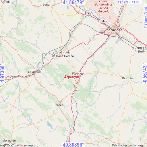
| Map corner | latitude | longitude |
|---|---|---|
| Upper-left | 41.86479°, | -1.97368° |
| Center: | 41.33901°, | -1.27055° |
| Lower-right: | 40.80896°, | -0.56743° |
| Map W x H: | 117.4×117.4 km | = 72.9×72.9mi |
| max Lat: | 43.74134° ⇑44% North |
| Aguarón: | 41.33901° |
| min Lat: | ⇓56% South 27.64134° |
| min Long | Aguarón | max Long |
| -18.00367° | -1.27055° | 4.2899° |
| W 75%⇐ | ⇒25% E |
Elevation
Elevation of Aguarón is 644 m = 2113 ft, and this is 46 m = 151 ft above average elevation for this country.
| Max E: |
1682 m = 5518 ft | 51.4% |
| Aguarón | 644 m 2113 ft | |
| Avg. | 598 m = 1962 ft | |
Min E: |
0 m = 0 ft | 48.6% |
See also: Spain elevation on elevation.city.
Geographical zone
Aguarón is located in North temperate zone (between Tropic of Cancer and the Arctic Circle). Distance of this Northern Tropic circle is 1990.5 km =1236.8 mi to South.| Distance of | km | miles | from Aguarón |
|---|---|---|---|
| North Pole | 5410.6 | 3362 | to North |
| Arctic Circle | 2804.7 | 1742.8 | to North |
| Tropic Cancer | 1990.5 | 1236.8 | to South |
| Equator | 4596.5 | 2856.1 | to South |


Nearby cities:
15 places around Aguarón: (largest is in red/bold)
• Aladrén
13.8 km =8.6 mi,  136°
136°
• Alfamén
11.3 km =7 mi,  11°
11°
• Almonacid de la Sierra
7.9 km =4.9 mi,  325°
325°
• Alpartir
13.1 km =8.1 mi,  315°
315°
• Cariñena
3.9 km =2.4 mi,  92°
92°
• Cerveruela
14.5 km =9 mi,  161°
161°
• Codos
10.1 km =6.3 mi,  239°
239°
• Cosuenda
3.8 km =2.4 mi, 321°
• Encinacorba
6 km =3.7 mi,  183°
183°
• Longares
11.1 km =6.9 mi,  50°
50°
• Mainar
16.5 km =10.3 mi,  189°
189°
• Paniza
7.8 km =4.8 mi, 141°
• Santa Cruz de Grío
13.8 km =8.6 mi,  284°
284°
• Tobed
10.8 km =6.7 mi,  269°
269°
• Torralbilla
15.4 km =9.6 mi,  201°
201°
Sources, notices
• [Note1] Compared only with cities in Spain existing in our database
• [Src1] Map data: © OpenStreetMap contributors (CC-BY-SA)
• [Src2] Other city data from geonames.org with taken over terms of usage.
• [Src3] Geographical zone / Annual Mean Temperature by Robert A. Rohde @ Wikipedia
