Cosuenda geodata
Cosuenda (Aragon) is a seat of a third-order administrative division; located in Spain in Europe/Madrid (GMT+2) time zone. With population of 387 people, there are 4176 cities with bigger population in this country. Compared to other cities in Spain, 56.6% of cities are located further ↓South; 74.8% of cities are located further ←West and 53% of cities have higher elevation than Cosuenda. Note1


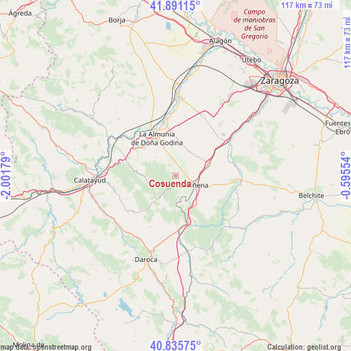
Cosuenda GPS coordinates[2]
41° 21' 56.124" North, 1° 17' 55.212" West
| Map corner | latitude | longitude |
|---|---|---|
| Upper-left | 41.89115°, | -2.00179° |
| Center: | 41.36559°, | -1.29867° |
| Lower-right: | 40.83575°, | -0.59554° |
| Map W x H: | 117.3×117.3 km | = 72.9×72.9mi |
| max Lat: | 43.74134° ⇑43.4% North |
| Cosuenda: | 41.36559° |
| min Lat: | ⇓56.6% South 27.64134° |
| min Long | Cosuenda | max Long |
| -18.00367° | -1.29867° | 4.2899° |
| W 74.8%⇐ | ⇒25.2% E |
Elevation
Elevation of Cosuenda is 623 m = 2044 ft, and this is 25 m = 82 ft above average elevation for this country.
| Max E: |
1682 m = 5518 ft | 53% |
| Cosuenda | 623 m 2044 ft | |
| Avg. | 598 m = 1962 ft | |
Min E: |
0 m = 0 ft | 47% |
See also: Spain elevation on elevation.city.
Geographical zone
Cosuenda is located in North temperate zone (between Tropic of Cancer and the Arctic Circle). Distance of this Northern Tropic circle is 1993.5 km =1238.7 mi to South.| Distance of | km | miles | from Cosuenda |
|---|---|---|---|
| North Pole | 5407.6 | 3360.1 | to North |
| Arctic Circle | 2801.8 | 1741 | to North |
| Tropic Cancer | 1993.5 | 1238.7 | to South |
| Equator | 4599.4 | 2857.9 | to South |


Nearby cities:
15 places around Cosuenda: (largest is in red/bold)
• Aguarón
3.8 km =2.4 mi,  141°
141°
• Aladrén
17.6 km =10.9 mi, 137°
• Alfamén
9.3 km =5.8 mi,  28°
28°
• Almonacid de la Sierra
4.1 km =2.5 mi,  329°
329°
• Alpartir
9.3 km =5.8 mi,  312°
312°
• Cariñena
6.9 km =4.3 mi,  116°
116°
• Codos
10.3 km =6.4 mi,  217°
217°
• El Frasno
17.3 km =10.7 mi,  288°
288°
• Encinacorba
9.2 km =5.7 mi,  167°
167°
• La Almunia de Doña Godina
13.9 km =8.6 mi, 332°
• Longares
11.6 km =7.2 mi,  68°
68°
• Orera
16.8 km =10.4 mi,  243°
243°
• Paniza
11.6 km =7.2 mi, 141°
• Santa Cruz de Grío
11 km =6.8 mi,  272°
272°
• Tobed
9 km =5.6 mi,  250°
250°
Sources, notices
• [Note1] Compared only with cities in Spain existing in our database
• [Src1] Map data: © OpenStreetMap contributors (CC-BY-SA)
• [Src2] Other city data from geonames.org with taken over terms of usage.
• [Src3] Geographical zone / Annual Mean Temperature by Robert A. Rohde @ Wikipedia
