Leganés geodata
Leganés (Madrid) is a seat of a third-order administrative division; located in Spain in Europe/Madrid (GMT+2) time zone. With population of 186,066 people, there are 39 cities with bigger population in this country. Compared to other cities in Spain, 65.3% of cities are located further ↑North; 56.2% of cities are located further →East and 51.2% of cities have lower elevation than Leganés. Note1


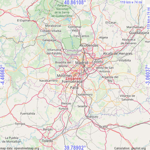
Leganés GPS coordinates[2]
40° 19' 37.848" North, 3° 45' 48.6" West
| Map corner | latitude | longitude |
|---|---|---|
| Upper-left | 40.86108°, | -4.46662° |
| Center: | 40.32718°, | -3.7635° |
| Lower-right: | 39.78902°, | -3.06037° |
| Map W x H: | 119.2×119.2 km | = 74.1×74.1mi |
| max Lat: | 43.74134° ⇑65.3% North |
| Leganés: | 40.32718° |
| min Lat: | ⇓34.7% South 27.64134° |
| min Long | Leganés | max Long |
| -18.00367° | -3.7635° | 4.2899° |
| W 43.8%⇐ | ⇒56.2% E |
Elevation
Elevation of Leganés is 672 m = 2205 ft, and this is 74 m = 243 ft above average elevation for this country.
| Max E: |
1682 m = 5518 ft | 48.8% |
| Leganés | 672 m 2205 ft | |
| Avg. | 598 m = 1962 ft | |
Min E: |
0 m = 0 ft | 51.2% |
See also: Leganés elevation on elevation.city.
Geographical zone
Leganés is located in North temperate zone (between Tropic of Cancer and the Arctic Circle). Distance of this Northern Tropic circle is 1878 km =1166.9 mi to South.| Distance of | km | miles | from Leganés |
|---|---|---|---|
| North Pole | 5523.1 | 3431.9 | to North |
| Arctic Circle | 2917.2 | 1812.7 | to North |
| Tropic Cancer | 1878 | 1166.9 | to South |
| Equator | 4484 | 2786.2 | to South |


Nearby cities:
15 places around Leganés: (largest is in red/bold)
• Alcorcón
5.6 km =3.5 mi,  291°
291°
• Arganzuela
9.9 km =6.2 mi,  35°
35°
• Carabanchel
7.8 km =4.8 mi,  25°
25°
• Fuenlabrada
5.4 km =3.4 mi,  208°
208°
• Getafe
3.5 km =2.2 mi,  132°
132°
• Humanes de Madrid
10.3 km =6.4 mi, 213°
• Latina
7 km =4.3 mi,  12°
12°
• Madrid
11.2 km =7 mi, 27°
• Moraleja de Enmedio
11 km =6.8 mi,  228°
228°
• Móstoles
8.6 km =5.3 mi,  266°
266°
• Parla
10.1 km =6.3 mi,  181°
181°
• Pinto
10.9 km =6.8 mi,  150°
150°
• Puente de Vallecas
11.3 km =7 mi,  49°
49°
• Usera
8.7 km =5.4 mi, 38°
• Villaverde
5.9 km =3.7 mi,  64°
64°
Sources, notices
• [Note1] Compared only with cities in Spain existing in our database
• [Src1] Map data: © OpenStreetMap contributors (CC-BY-SA)
• [Src2] Other city data from geonames.org with taken over terms of usage.
• [Src3] Geographical zone / Annual Mean Temperature by Robert A. Rohde @ Wikipedia
