Getafe geodata
Getafe (Madrid) is a seat of a third-order administrative division; located in Spain in Europe/Madrid (GMT+2) time zone. With population of 167,164 people, there are 48 cities with bigger population in this country. Compared to other cities in Spain, 65.6% of cities are located further ↑North; 55.8% of cities are located further →East and 52.1% of cities have higher elevation than Getafe. Note1


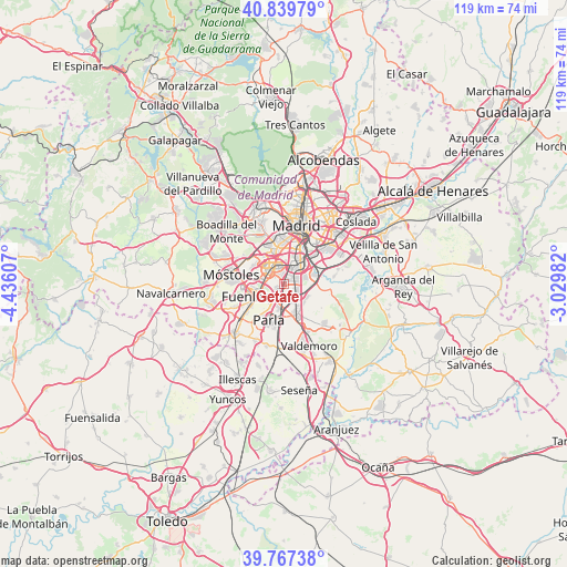
Getafe GPS coordinates[2]
40° 18' 20.556" North, 3° 43' 58.62" West
| Map corner | latitude | longitude |
|---|---|---|
| Upper-left | 40.83979°, | -4.43607° |
| Center: | 40.30571°, | -3.73295° |
| Lower-right: | 39.76738°, | -3.02982° |
| Map W x H: | 119.2×119.2 km | = 74.1×74.1mi |
| max Lat: | 43.74134° ⇑65.6% North |
| Getafe: | 40.30571° |
| min Lat: | ⇓34.4% South 27.64134° |
| min Long | Getafe | max Long |
| -18.00367° | -3.73295° | 4.2899° |
| W 44.2%⇐ | ⇒55.8% E |
Elevation
Elevation of Getafe is 636 m = 2087 ft, and this is 38 m = 125 ft above average elevation for this country.
| Max E: |
1682 m = 5518 ft | 52.1% |
| Getafe | 636 m 2087 ft | |
| Avg. | 598 m = 1962 ft | |
Min E: |
0 m = 0 ft | 47.9% |
See also: Getafe elevation on elevation.city.
Geographical zone
Getafe is located in North temperate zone (between Tropic of Cancer and the Arctic Circle). Distance of this Northern Tropic circle is 1875.7 km =1165.5 mi to South.| Distance of | km | miles | from Getafe |
|---|---|---|---|
| North Pole | 5525.5 | 3433.4 | to North |
| Arctic Circle | 2919.6 | 1814.2 | to North |
| Tropic Cancer | 1875.7 | 1165.5 | to South |
| Equator | 4481.6 | 2784.7 | to South |


Nearby cities:
15 places around Getafe: (largest is in red/bold)
• Alcorcón
9 km =5.6 mi,  299°
299°
• Arganzuela
11 km =6.8 mi,  16°
16°
• Carabanchel
9.5 km =5.9 mi,  4°
4°
• Fuenlabrada
5.7 km =3.5 mi,  245°
245°
• Humanes de Madrid
10.3 km =6.4 mi,  233°
233°
• Latina
9.3 km =5.8 mi,  353°
353°
• Leganés
3.5 km =2.2 mi,  312°
312°
• Madrid
12.6 km =7.8 mi,  11°
11°
• Moraleja de Enmedio
11.8 km =7.3 mi, 245°
• Móstoles
11.3 km =7 mi,  279°
279°
• Parla
8.3 km =5.2 mi,  200°
200°
• Pinto
7.7 km =4.8 mi,  158°
158°
• Puente de Vallecas
11.5 km =7.1 mi,  31°
31°
• Usera
9.6 km =6 mi, 16°
• Villaverde
5.7 km =3.5 mi, 29°
Sources, notices
• [Note1] Compared only with cities in Spain existing in our database
• [Src1] Map data: © OpenStreetMap contributors (CC-BY-SA)
• [Src2] Other city data from geonames.org with taken over terms of usage.
• [Src3] Geographical zone / Annual Mean Temperature by Robert A. Rohde @ Wikipedia
