La Restinga geodata
La Restinga (Canary Islands) is a populated place; located in Spain in Atlantic/Canary (GMT+1) time zone. With population of 541 people, there are 3760 cities with bigger population in this country. Compared to other cities in Spain, 100% of cities are located further ↑North; 100% of cities are located further →East and 95.4% of cities have higher elevation than La Restinga. Note1
Administrative division(s):
- Level 1: Canary Islands
- Level 2: Provincia de Santa Cruz de Tenerife
- Level 3: El Pinar de El Hierro


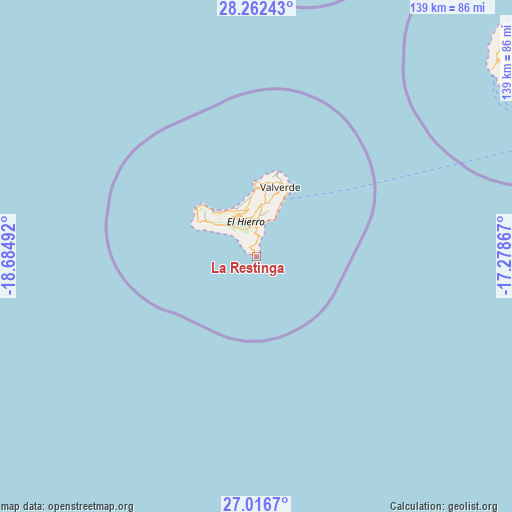
La Restinga GPS coordinates[2]
27° 38' 28.824" North, 17° 58' 54.444" West
| Map corner | latitude | longitude |
|---|---|---|
| Upper-left | 28.26243°, | -18.68492° |
| Center: | 27.64134°, | -17.98179° |
| Lower-right: | 27.0167°, | -17.27867° |
| Map W x H: | 138.5×138.5 km | = 86.1×86.1mi |
| max Lat: | 43.74134° ⇑100% North |
| La Restinga: | 27.64134° |
| min Lat: | ⇓0% South 27.64134° |
| min Long | La Restinga | max Long |
| -18.00367° | -17.98179° | 4.2899° |
| W 0%⇐ | ⇒100% E |
Elevation
Elevation of La Restinga is 23 m = 75 ft, and this is 575 m = 1886 ft below average elevation for this country.
| Max E: |
1682 m = 5518 ft | 95.4% |
| Avg. | 598 m = 1962 ft | |
| La Restinga | 23 m = 75 ft | |
Min E: |
0 m = 0 ft | 4.6% |
See also: Spain elevation on elevation.city.
Geographical zone
La Restinga is located in North temperate zone (between Tropic of Cancer and the Arctic Circle). Distance of this Northern Tropic circle is 467.5 km =290.5 mi to South.| Distance of | km | miles | from La Restinga |
|---|---|---|---|
| North Pole | 6933.6 | 4308.3 | to North |
| Arctic Circle | 4327.7 | 2689.1 | to North |
| Tropic Cancer | 467.5 | 290.5 | to South |
| Equator | 3073.4 | 1909.7 | to South |


Nearby cities:
15 places around La Restinga: (largest is in red/bold)
• Agulo
98.2 km =61 mi,  51°
51°
• Alajeró
86.6 km =53.8 mi,  57°
57°
• Breña Baja
111.5 km =69.3 mi,  9°
9°
• El Paso
112.6 km =70 mi,  4°
4°
• Frontera
12.7 km =7.9 mi,  350°
350°
• Fuencaliente de la Palma
95.6 km =59.4 mi, 8°
• Hermigua
97.3 km =60.5 mi, 53°
• Los Llanos de Aridane
113.3 km =70.4 mi, 3°
• Mazo
109.4 km =68 mi, 10°
• Playa de Santiago
88.3 km =54.9 mi, 60°
• Puerto Naos
105.3 km =65.4 mi, 3°
• San Sebastián de la Gomera
99 km =61.5 mi, 59°
• Tazacorte
111.3 km =69.2 mi, 2°
• Vallehermosa
92.3 km =57.4 mi, 49°
• Valverde
19.5 km =12.1 mi,  19°
19°
Sources, notices
• [Note1] Compared only with cities in Spain existing in our database
• [Src1] Map data: © OpenStreetMap contributors (CC-BY-SA)
• [Src2] Other city data from geonames.org with taken over terms of usage.
• [Src3] Geographical zone / Annual Mean Temperature by Robert A. Rohde @ Wikipedia
