Hamina geodata
Hamina (Kymenlaakso) is a seat of a third-order administrative division; located in Finland in Europe/Helsinki (GMT+3) time zone. With population of 21,712 people, there are 48 cities with bigger population in this country. Compared to other cities in Finland, 82.3% of cities are located further ↑North; 81.4% of cities are located further ←West and 97.9% of cities have higher elevation than Hamina. Note1


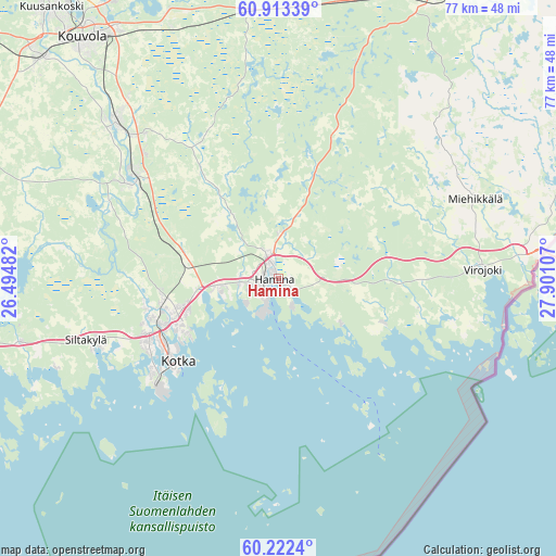
Hamina GPS coordinates[2]
60° 34' 11.064" North, 27° 11' 52.584" East
| Map corner | latitude | longitude |
|---|---|---|
| Upper-left | 60.91339°, | 26.49482° |
| Center: | 60.56974°, | 27.19794° |
| Lower-right: | 60.2224°, | 27.90107° |
| Map W x H: | 76.8×76.8 km | = 47.7×47.7mi |
| max Lat: | 69.90864° ⇑82.3% North |
| Hamina: | 60.56974° |
| min Lat: | ⇓17.7% South 59.83333° |
| min Long | Hamina | max Long |
| 21.2° | 27.19794° | 30.93276° |
| W 81.4%⇐ | ⇒18.6% E |
Elevation
Elevation of Hamina is 3 m = 10 ft, and this is 74.1 m = 243 ft below average elevation for this country.
| Max E: |
299 m = 981 ft | 97.9% |
| Avg. | 77.1 m = 253 ft | |
| Hamina | 3 m = 10 ft | |
Min E: |
1 m = 3 ft | 2.1% |
See also: Finland elevation on elevation.city.
Geographical zone
Hamina is located in North temperate zone (between Tropic of Cancer and the Arctic Circle). Distance of this North polar circle is 666.5 km =414.1 mi to North.| Distance of | km | miles | from Hamina |
|---|---|---|---|
| North Pole | 3272.3 | 2033.3 | to North |
| Arctic Circle | 666.5 | 414.1 | to North |
| Tropic Cancer | 4128.8 | 2565.5 | to South |
| Equator | 6734.7 | 4184.7 | to South |


Nearby cities:
15 places around Hamina: (largest is in red/bold)
• Anjala
23.6 km =14.7 mi,  302°
302°
• Broby
27.4 km =17 mi,  253°
253°
• Elimäki
43.1 km =26.8 mi,  292°
292°
• Karhula
15.5 km =9.6 mi, 249°
• Katariina
19.1 km =11.9 mi,  227°
227°
• Kotka
18 km =11.2 mi, 230°
• Kouvola
42.7 km =26.5 mi,  320°
320°
• Luumäki
44.8 km =27.8 mi,  27°
27°
• Miehikkälä
29.4 km =18.3 mi,  68°
68°
• Pyhtää
36.8 km =22.9 mi,  256°
256°
• Ruotsinpyhtää
40.5 km =25.2 mi, 263°
• Taavetti
43.5 km =27 mi, 27°
• Virojoki
27.6 km =17.1 mi,  87°
87°
• Virolahti
27.2 km =16.9 mi,  102°
102°
• Ylämaa
50.6 km =31.4 mi,  59°
59°
Sources, notices
• [Note1] Compared only with cities in Finland existing in our database
• [Src1] Map data: © OpenStreetMap contributors (CC-BY-SA)
• [Src2] Other city data from geonames.org with taken over terms of usage.
• [Src3] Geographical zone / Annual Mean Temperature by Robert A. Rohde @ Wikipedia
