Pyhtää geodata
Pyhtää (Kymenlaakso) is a populated place; located in Finland in Europe/Helsinki (GMT+3) time zone. With population of 4,964 people, there are 208 cities with bigger population in this country. Compared to other cities in Finland, 85.5% of cities are located further ↑North; 76.1% of cities are located further ←West and 93.4% of cities have higher elevation than Pyhtää. Note1


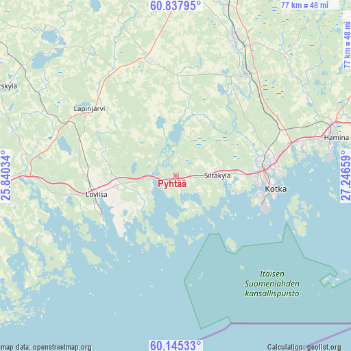
Pyhtää GPS coordinates[2]
60° 29' 36.564" North, 26° 32' 36.456" East
| Map corner | latitude | longitude |
|---|---|---|
| Upper-left | 60.83795°, | 25.84034° |
| Center: | 60.49349°, | 26.54346° |
| Lower-right: | 60.14533°, | 27.24659° |
| Map W x H: | 77×77 km | = 47.8×47.8mi |
| max Lat: | 69.90864° ⇑85.5% North |
| Pyhtää: | 60.49349° |
| min Lat: | ⇓14.5% South 59.83333° |
| min Long | Pyhtää | max Long |
| 21.2° | 26.54346° | 30.93276° |
| W 76.1%⇐ | ⇒23.9% E |
Elevation
Elevation of Pyhtää is 9 m = 30 ft, and this is 68.1 m = 223 ft below average elevation for this country.
| Max E: |
299 m = 981 ft | 93.4% |
| Avg. | 77.1 m = 253 ft | |
| Pyhtää | 9 m = 30 ft | |
Min E: |
1 m = 3 ft | 6.6% |
See also: Finland elevation on elevation.city.
Geographical zone
Pyhtää is located in North temperate zone (between Tropic of Cancer and the Arctic Circle). Distance of this North polar circle is 674.9 km =419.4 mi to North.| Distance of | km | miles | from Pyhtää |
|---|---|---|---|
| North Pole | 3280.8 | 2038.6 | to North |
| Arctic Circle | 674.9 | 419.4 | to North |
| Tropic Cancer | 4120.3 | 2560.2 | to South |
| Equator | 6726.2 | 4179.5 | to South |


Nearby cities:
15 places around Pyhtää: (largest is in red/bold)
• Anjala
26.4 km =16.4 mi,  36°
36°
• Artjärvi
38.1 km =23.7 mi,  317°
317°
• Broby
9.5 km =5.9 mi,  85°
85°
• Elimäki
25.2 km =15.7 mi,  350°
350°
• Hamina
36.8 km =22.9 mi,  76°
76°
• Karhula
21.5 km =13.4 mi, 81°
• Katariina
22.3 km =13.9 mi,  101°
101°
• Kotka
22.2 km =13.8 mi, 97°
• Kouvola
42.4 km =26.3 mi,  11°
11°
• Lapinjärvi
23.9 km =14.9 mi,  307°
307°
• Liljendal
28.3 km =17.6 mi,  288°
288°
• Lovisa
17.9 km =11.1 mi,  256°
256°
• Myrskylä
42.8 km =26.6 mi,  297°
297°
• Pernå
28.5 km =17.7 mi, 259°
• Ruotsinpyhtää
5.8 km =3.6 mi, 309°
Sources, notices
• [Note1] Compared only with cities in Finland existing in our database
• [Src1] Map data: © OpenStreetMap contributors (CC-BY-SA)
• [Src2] Other city data from geonames.org with taken over terms of usage.
• [Src3] Geographical zone / Annual Mean Temperature by Robert A. Rohde @ Wikipedia
