Kotka geodata
Kotka (Kymenlaakso) is a seat of a third-order administrative division; located in Finland in Europe/Helsinki (GMT+3) time zone. With population of 54,616 people, there are 12 cities with bigger population in this country. Compared to other cities in Finland, 87.2% of cities are located further ↑North; 79.5% of cities are located further ←West and 100% of cities have higher elevation than Kotka. Note1


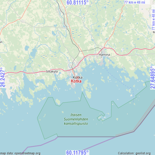
Kotka GPS coordinates[2]
60° 27' 59.04" North, 26° 56' 44.952" East
| Map corner | latitude | longitude |
|---|---|---|
| Upper-left | 60.81115°, | 26.2427° |
| Center: | 60.4664°, | 26.94582° |
| Lower-right: | 60.11795°, | 27.64895° |
| Map W x H: | 77.1×77.1 km | = 47.9×47.9mi |
| max Lat: | 69.90864° ⇑87.2% North |
| Kotka: | 60.4664° |
| min Lat: | ⇓12.8% South 59.83333° |
| min Long | Kotka | max Long |
| 21.2° | 26.94582° | 30.93276° |
| W 79.5%⇐ | ⇒20.5% E |
Elevation
Elevation of Kotka is 1 m = 3 ft, and this is 76.1 m = 250 ft below average elevation for this country.
| Max E: |
299 m = 981 ft | 100% |
| Avg. | 77.1 m = 253 ft | |
| Kotka | 1 m = 3 ft | |
Min E: |
1 m = 3 ft | 0% |
See also: Kotka elevation on elevation.city.
Geographical zone
Kotka is located in North temperate zone (between Tropic of Cancer and the Arctic Circle). Distance of this North polar circle is 677.9 km =421.2 mi to North.| Distance of | km | miles | from Kotka |
|---|---|---|---|
| North Pole | 3283.8 | 2040.5 | to North |
| Arctic Circle | 677.9 | 421.2 | to North |
| Tropic Cancer | 4117.3 | 2558.4 | to South |
| Equator | 6723.2 | 4177.6 | to South |


Nearby cities:
15 places around Kotka: (largest is in red/bold)
• Anjala
24.9 km =15.5 mi,  345°
345°
• Broby
13.1 km =8.1 mi,  286°
286°
• Elimäki
38.2 km =23.7 mi,  316°
316°
• Hamina
18 km =11.2 mi,  50°
50°
• Karhula
6.2 km =3.9 mi, 352°
• Katariina
1.5 km =0.9 mi,  186°
186°
• Kouvola
46.5 km =28.9 mi,  343°
343°
• Lapinjärvi
44.5 km =27.7 mi, 293°
• Lovisa
39.5 km =24.5 mi,  268°
268°
• Miehikkälä
46.8 km =29.1 mi,  61°
61°
• Pernå
50.1 km =31.1 mi, 267°
• Pyhtää
22.2 km =13.8 mi,  277°
277°
• Ruotsinpyhtää
27.3 km =17 mi, 284°
• Virojoki
43.3 km =26.9 mi,  73°
73°
• Virolahti
40.8 km =25.4 mi,  82°
82°
Sources, notices
• [Note1] Compared only with cities in Finland existing in our database
• [Src1] Map data: © OpenStreetMap contributors (CC-BY-SA)
• [Src2] Other city data from geonames.org with taken over terms of usage.
• [Src3] Geographical zone / Annual Mean Temperature by Robert A. Rohde @ Wikipedia
