Chemilly geodata
Chemilly (Auvergne-Rhône-Alpes) is a populated place; located in France in Europe/Paris (GMT+2) time zone. With population of 585 people, there are 13555 cities with bigger population in this country. Compared to other cities in France, 60.2% of cities are located further ↑North; 62.2% of cities are located further ←West and 70.4% of cities have lower elevation than Chemilly. Note1
Administrative division(s):
- Level 1: Auvergne-Rhône-Alpes
- Level 2: Département de l'Allier
- Level 3: Arrondissement de Moulins
- Level 4: Chemilly


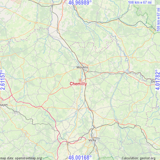
Chemilly GPS coordinates[2]
46° 29' 16.584" North, 3° 18' 52.884" East
| Map corner | latitude | longitude |
|---|---|---|
| Upper-left | 46.96989°, | 2.61157° |
| Center: | 46.48794°, | 3.31469° |
| Lower-right: | 46.00168°, | 4.01782° |
| Map W x H: | 107.7×107.7 km | = 66.9×66.9mi |
| max Lat: | 51.07786° ⇑60.2% North |
| Chemilly: | 46.48794° |
| min Lat: | ⇓39.8% South 41.3874° |
| min Long | Chemilly | max Long |
| -5.08615° | 3.31469° | 9.52242° |
| W 62.2%⇐ | ⇒37.8% E |
Elevation
Elevation of Chemilly is 221 m = 725 ft, and this is 27.3 m = 90 ft above average elevation for this country.
| Max E: |
2333 m = 7654 ft | 29.6% |
| Chemilly | 221 m 725 ft | |
| Avg. | 193.7 m = 635 ft | |
Min E: |
-1 m = -3 ft | 70.4% |
See also: France elevation on elevation.city.
Geographical zone
Chemilly is located in North temperate zone (between Tropic of Cancer and the Arctic Circle). Distance of this North polar circle is 2232.2 km =1387 mi to North.| Distance of | km | miles | from Chemilly |
|---|---|---|---|
| North Pole | 4838.1 | 3006.3 | to North |
| Arctic Circle | 2232.2 | 1387 | to North |
| Tropic Cancer | 2563.1 | 1592.6 | to South |
| Equator | 5169 | 3211.9 | to South |


Nearby cities:
15 places around Chemilly: (largest is in red/bold)
• Avermes
11.1 km =6.9 mi,  357°
357°
• Bessay-sur-Allier
6.3 km =3.9 mi,  144°
144°
• Besson
4.4 km =2.7 mi,  242°
242°
• Bressolles
4.8 km =3 mi,  1°
1°
• Châtel-de-Neuvre
9.1 km =5.7 mi,  181°
181°
• Coulandon
8.3 km =5.2 mi,  327°
327°
• Cressanges
12.7 km =7.9 mi,  248°
248°
• Montbeugny
14.1 km =8.8 mi,  71°
71°
• Montilly
14.6 km =9.1 mi,  340°
340°
• Moulins
8.6 km =5.3 mi,  9°
9°
• Neuilly-le-Réal
9.4 km =5.8 mi,  106°
106°
• Neuvy
8.4 km =5.2 mi,  347°
347°
• Souvigny
10.7 km =6.6 mi,  299°
299°
• Toulon-sur-Allier
4.8 km =3 mi,  45°
45°
• Yzeure
9.2 km =5.7 mi,  19°
19°
Sources, notices
• [Note1] Compared only with cities in France existing in our database
• [Src1] Map data: © OpenStreetMap contributors (CC-BY-SA)
• [Src2] Other city data from geonames.org with taken over terms of usage.
• [Src3] Geographical zone / Annual Mean Temperature by Robert A. Rohde @ Wikipedia
