Ymare geodata
Ymare (Normandy) is a populated place; located in France in Europe/Paris (GMT+2) time zone. With population of 1,060 people, there are 8398 cities with bigger population in this country. Compared to other cities in France, 87% of cities are located further ↓South; 67% of cities are located further →East and 51.9% of cities have lower elevation than Ymare. Note1
Administrative division(s):
- Level 1: Normandy
- Level 2: Seine-Maritime
- Level 3: Arrondissement de Rouen
- Level 4: Ymare


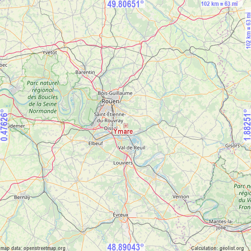
Ymare GPS coordinates[2]
49° 21' 2.16" North, 1° 10' 45.768" East
| Map corner | latitude | longitude |
|---|---|---|
| Upper-left | 49.80651°, | 0.47626° |
| Center: | 49.3506°, | 1.17938° |
| Lower-right: | 48.89043°, | 1.88251° |
| Map W x H: | 101.9×101.9 km | = 63.3×63.3mi |
| max Lat: | 51.07786° ⇑13% North |
| Ymare: | 49.3506° |
| min Lat: | ⇓87% South 41.3874° |
| min Long | Ymare | max Long |
| -5.08615° | 1.17938° | 9.52242° |
| W 33%⇐ | ⇒67% E |
Elevation
Elevation of Ymare is 139 m = 456 ft, and this is 54.7 m = 179 ft below average elevation for this country.
| Max E: |
2333 m = 7654 ft | 48.1% |
| Avg. | 193.7 m = 635 ft | |
| Ymare | 139 m = 456 ft | |
Min E: |
-1 m = -3 ft | 51.9% |
See also: France elevation on elevation.city.
Geographical zone
Ymare is located in North temperate zone (between Tropic of Cancer and the Arctic Circle). Distance of this North polar circle is 1913.9 km =1189.2 mi to North.| Distance of | km | miles | from Ymare |
|---|---|---|---|
| North Pole | 4519.8 | 2808.5 | to North |
| Arctic Circle | 1913.9 | 1189.2 | to North |
| Tropic Cancer | 2881.4 | 1790.4 | to South |
| Equator | 5487.3 | 3409.6 | to South |


Nearby cities:
15 places around Ymare: (largest is in red/bold)
• Alizay
3.2 km =2 mi,  181°
181°
• Belbeuf
4.9 km =3 mi,  327°
327°
• Boos
4.6 km =2.9 mi,  22°
22°
• Gouy
2.2 km =1.4 mi,  279°
279°
• Igoville
4.1 km =2.5 mi,  213°
213°
• Le Manoir
4.5 km =2.8 mi,  156°
156°
• Les Authieux-sur-le-Port-Saint-Ouen
3.4 km =2.1 mi,  251°
251°
• Les Damps
5.4 km =3.4 mi, 181°
• Pîtres
5.4 km =3.4 mi,  133°
133°
• Quévreville-la-Poterie
0.9 km =0.6 mi,  55°
55°
• Romilly-sur-Andelle
6.3 km =3.9 mi,  109°
109°
• Saint-Aubin-Celloville
2 km =1.2 mi,  315°
315°
• Saint-Étienne-du-Rouvray
6.2 km =3.9 mi,  299°
299°
• Sotteville-sous-le-Val
5.3 km =3.3 mi,  228°
228°
• Tourville-la-Rivière
5.9 km =3.7 mi,  244°
244°
Sources, notices
• [Note1] Compared only with cities in France existing in our database
• [Src1] Map data: © OpenStreetMap contributors (CC-BY-SA)
• [Src2] Other city data from geonames.org with taken over terms of usage.
• [Src3] Geographical zone / Annual Mean Temperature by Robert A. Rohde @ Wikipedia
