Gouy geodata
Gouy (Normandy) is a populated place; located in France in Europe/Paris (GMT+2) time zone. With population of 810 people, there are 10481 cities with bigger population in this country. Compared to other cities in France, 87.1% of cities are located further ↓South; 67.4% of cities are located further →East and 69.7% of cities have higher elevation than Gouy. Note1
Administrative division(s):
- Level 1: Normandy
- Level 2: Seine-Maritime
- Level 3: Arrondissement de Rouen
- Level 4: Gouy


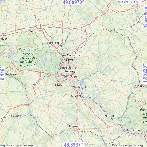
Gouy GPS coordinates[2]
49° 21' 13.824" North, 1° 8' 56.832" East
| Map corner | latitude | longitude |
|---|---|---|
| Upper-left | 49.80972°, | 0.446° |
| Center: | 49.35384°, | 1.14912° |
| Lower-right: | 48.8937°, | 1.85225° |
| Map W x H: | 101.9×101.8 km | = 63.3×63.3mi |
| max Lat: | 51.07786° ⇑12.9% North |
| Gouy: | 49.35384° |
| min Lat: | ⇓87.1% South 41.3874° |
| min Long | Gouy | max Long |
| -5.08615° | 1.14912° | 9.52242° |
| W 32.6%⇐ | ⇒67.4% E |
Elevation
Elevation of Gouy is 79 m = 259 ft, and this is 114.7 m = 376 ft below average elevation for this country.
| Max E: |
2333 m = 7654 ft | 69.7% |
| Avg. | 193.7 m = 635 ft | |
| Gouy | 79 m = 259 ft | |
Min E: |
-1 m = -3 ft | 30.3% |
See also: France elevation on elevation.city.
Geographical zone
Gouy is located in North temperate zone (between Tropic of Cancer and the Arctic Circle). Distance of this North polar circle is 1913.5 km =1189 mi to North.| Distance of | km | miles | from Gouy |
|---|---|---|---|
| North Pole | 4519.4 | 2808.2 | to North |
| Arctic Circle | 1913.5 | 1189 | to North |
| Tropic Cancer | 2881.7 | 1790.6 | to South |
| Equator | 5487.6 | 3409.8 | to South |


Nearby cities:
15 places around Gouy: (largest is in red/bold)
• Alizay
4.2 km =2.6 mi,  149°
149°
• Amfreville-la-Mi-Voie
6 km =3.7 mi,  352°
352°
• Belbeuf
3.8 km =2.4 mi, 352°
• Boos
5.5 km =3.4 mi,  45°
45°
• Igoville
3.8 km =2.4 mi,  180°
180°
• Le Manoir
6 km =3.7 mi,  138°
138°
• Les Authieux-sur-le-Port-Saint-Ouen
1.8 km =1.1 mi,  216°
216°
• Les Damps
6.1 km =3.8 mi,  160°
160°
• Oissel
4.6 km =2.9 mi,  239°
239°
• Quévreville-la-Poterie
3 km =1.9 mi,  86°
86°
• Saint-Aubin-Celloville
1.3 km =0.8 mi,  35°
35°
• Saint-Étienne-du-Rouvray
4.2 km =2.6 mi,  309°
309°
• Sotteville-sous-le-Val
4.3 km =2.7 mi,  205°
205°
• Tourville-la-Rivière
4.3 km =2.7 mi,  227°
227°
• Ymare
2.2 km =1.4 mi,  99°
99°
Sources, notices
• [Note1] Compared only with cities in France existing in our database
• [Src1] Map data: © OpenStreetMap contributors (CC-BY-SA)
• [Src2] Other city data from geonames.org with taken over terms of usage.
• [Src3] Geographical zone / Annual Mean Temperature by Robert A. Rohde @ Wikipedia
