Tourville-la-Rivière geodata
Tourville-la-Rivière (Normandy) is a populated place; located in France in Europe/Paris (GMT+2) time zone. With population of 2,336 people, there are 4129 cities with bigger population in this country. Compared to other cities in France, 86.6% of cities are located further ↓South; 67.8% of cities are located further →East and 94.7% of cities have higher elevation than Tourville-la-Rivière. Note1
Administrative division(s):
- Level 1: Normandy
- Level 2: Seine-Maritime
- Level 3: Arrondissement de Rouen
- Level 4: Tourville-la-Rivière


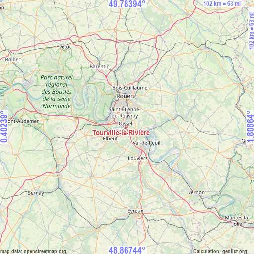
Tourville-la-Rivière GPS coordinates[2]
49° 19' 40.152" North, 1° 6' 19.836" East
| Map corner | latitude | longitude |
|---|---|---|
| Upper-left | 49.78394°, | 0.40239° |
| Center: | 49.32782°, | 1.10551° |
| Lower-right: | 48.86744°, | 1.80864° |
| Map W x H: | 101.9×101.9 km | = 63.3×63.3mi |
| max Lat: | 51.07786° ⇑13.4% North |
| Tourville-la-Rivière: | 49.32782° |
| min Lat: | ⇓86.6% South 41.3874° |
| min Long | Tourville-la-Ri | max Long |
| -5.08615° | 1.10551° | 9.52242° |
| W 32.2%⇐ | ⇒67.8% E |
Elevation
Elevation of Tourville-la-Rivière is 18 m = 59 ft, and this is 175.7 m = 576 ft below average elevation for this country.
| Max E: |
2333 m = 7654 ft | 94.7% |
| Avg. | 193.7 m = 635 ft | |
| Tourville-la-Rivière | 18 m = 59 ft | |
Min E: |
-1 m = -3 ft | 5.3% |
See also: France elevation on elevation.city.
Geographical zone
Tourville-la-Rivière is located in North temperate zone (between Tropic of Cancer and the Arctic Circle). Distance of this North polar circle is 1916.4 km =1190.8 mi to North.| Distance of | km | miles | from Tourville-la-Rivière |
|---|---|---|---|
| North Pole | 4522.3 | 2810 | to North |
| Arctic Circle | 1916.4 | 1190.8 | to North |
| Tropic Cancer | 2878.8 | 1788.8 | to South |
| Equator | 5484.7 | 3408 | to South |


Nearby cities:
15 places around Tourville-la-Rivière: (largest is in red/bold)
• Alizay
5.3 km =3.3 mi,  97°
97°
• Cléon
5.8 km =3.6 mi,  252°
252°
• Criquebeuf-sur-Seine
2.5 km =1.6 mi,  189°
189°
• Freneuse
2 km =1.2 mi,  232°
232°
• Gouy
4.3 km =2.7 mi,  47°
47°
• Igoville
3.2 km =2 mi,  105°
105°
• Les Authieux-sur-le-Port-Saint-Ouen
2.6 km =1.6 mi,  55°
55°
• Les Damps
6 km =3.7 mi,  118°
118°
• Oissel
1 km =0.6 mi,  305°
305°
• Quévreville-la-Poterie
6.8 km =4.2 mi, 63°
• Saint-Aubin-Celloville
5.6 km =3.5 mi,  44°
44°
• Saint-Pierre-lès-Elbeuf
7.1 km =4.4 mi,  219°
219°
• Saint-Étienne-du-Rouvray
5.6 km =3.5 mi,  359°
359°
• Sotteville-sous-le-Val
1.6 km =1 mi,  126°
126°
• Ymare
5.9 km =3.7 mi, 64°
Sources, notices
• [Note1] Compared only with cities in France existing in our database
• [Src1] Map data: © OpenStreetMap contributors (CC-BY-SA)
• [Src2] Other city data from geonames.org with taken over terms of usage.
• [Src3] Geographical zone / Annual Mean Temperature by Robert A. Rohde @ Wikipedia
