Saint-Aubin-Celloville geodata
Saint-Aubin-Celloville (Normandy) is a populated place; located in France in Europe/Paris (GMT+2) time zone. With population of 970 people, there are 9062 cities with bigger population in this country. Compared to other cities in France, 87.3% of cities are located further ↓South; 67.2% of cities are located further →East and 51.1% of cities have lower elevation than Saint-Aubin-Celloville. Note1
Administrative division(s):
- Level 1: Normandy
- Level 2: Seine-Maritime
- Level 3: Arrondissement de Rouen
- Level 4: Saint-Aubin-Celloville
Current local time in Saint-Aubin-Celloville:
08:37 AM, SaturdayDifference from your time zone: hours


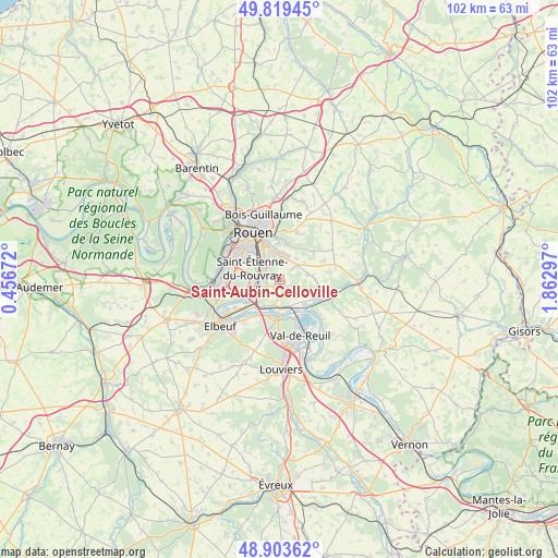
Saint-Aubin-Celloville GPS coordinates[2]
49° 21' 49.212" North, 1° 9' 35.424" East
| Map corner | latitude | longitude |
|---|---|---|
| Upper-left | 49.81945°, | 0.45672° |
| Center: | 49.36367°, | 1.15984° |
| Lower-right: | 48.90362°, | 1.86297° |
| Map W x H: | 101.8×101.8 km | = 63.3×63.3mi |
| max Lat: | 51.07786° ⇑12.7% North |
| Saint-Aubin-Celloville: | 49.36367° |
| min Lat: | ⇓87.3% South 41.3874° |
| min Long | Saint-Aubin-Cel | max Long |
| -5.08615° | 1.15984° | 9.52242° |
| W 32.8%⇐ | ⇒67.2% E |
Elevation
Elevation of Saint-Aubin-Celloville is 136 m = 446 ft, and this is 57.7 m = 189 ft below average elevation for this country.
| Max E: |
2333 m = 7654 ft | 48.9% |
| Avg. | 193.7 m = 635 ft | |
| Saint-Aubin-Celloville | 136 m = 446 ft | |
Min E: |
-1 m = -3 ft | 51.1% |
See also: France elevation on elevation.city.
Geographical zone
Saint-Aubin-Celloville is located in North temperate zone (between Tropic of Cancer and the Arctic Circle). Distance of this North polar circle is 1912.4 km =1188.3 mi to North.| Distance of | km | miles | from Saint-Aubin-Celloville |
|---|---|---|---|
| North Pole | 4518.3 | 2807.5 | to North |
| Arctic Circle | 1912.4 | 1188.3 | to North |
| Tropic Cancer | 2882.8 | 1791.3 | to South |
| Equator | 5488.7 | 3410.5 | to South |


Nearby cities:
15 places around Saint-Aubin-Celloville: (largest is in red/bold)
• Alizay
4.9 km =3 mi,  163°
163°
• Amfreville-la-Mi-Voie
5.1 km =3.2 mi,  342°
342°
• Belbeuf
2.9 km =1.8 mi,  334°
334°
• Boos
4.2 km =2.6 mi,  48°
48°
• Gouy
1.3 km =0.8 mi,  215°
215°
• Igoville
4.9 km =3 mi,  189°
189°
• Le Mesnil-Esnard
5.6 km =3.5 mi,  349°
349°
• Les Authieux-sur-le-Port-Saint-Ouen
3.1 km =1.9 mi, 215°
• Oissel
5.8 km =3.6 mi,  234°
234°
• Quévreville-la-Poterie
2.4 km =1.5 mi,  112°
112°
• Saint-Aubin-Épinay
5.9 km =3.7 mi,  4°
4°
• Saint-Étienne-du-Rouvray
4.3 km =2.7 mi,  291°
291°
• Sotteville-sous-le-Val
5.6 km =3.5 mi,  207°
207°
• Tourville-la-Rivière
5.6 km =3.5 mi, 224°
• Ymare
2 km =1.2 mi,  135°
135°
Sources, notices
• [Note1] Compared only with cities in France existing in our database
• [Src1] Map data: © OpenStreetMap contributors (CC-BY-SA)
• [Src2] Other city data from geonames.org with taken over terms of usage.
• [Src3] Geographical zone / Annual Mean Temperature by Robert A. Rohde @ Wikipedia
