Yerres geodata
Yerres (Île-de-France) is a populated place; located in France in Europe/Paris (GMT+2) time zone. With population of 28,897 people, there are 291 cities with bigger population in this country. Compared to other cities in France, 73.7% of cities are located further ↓South; 50.5% of cities are located further ←West and 72.3% of cities have higher elevation than Yerres. Note1
Administrative division(s):
- Level 1: Île-de-France
- Level 2: Département de l'Essonne
- Level 3: Arrondissement d'Évry
- Level 4: Yerres


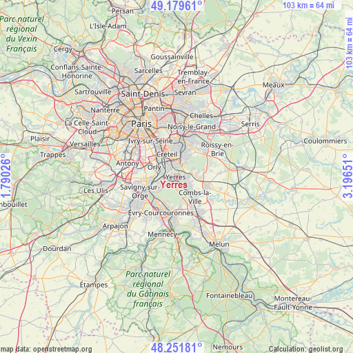
Yerres GPS coordinates[2]
48° 43' 4.26" North, 2° 29' 36.168" East
| Map corner | latitude | longitude |
|---|---|---|
| Upper-left | 49.17961°, | 1.79026° |
| Center: | 48.71785°, | 2.49338° |
| Lower-right: | 48.25181°, | 3.19651° |
| Map W x H: | 103.2×103.2 km | = 64.1×64.1mi |
| max Lat: | 51.07786° ⇑26.3% North |
| Yerres: | 48.71785° |
| min Lat: | ⇓73.7% South 41.3874° |
| min Long | Yerres | max Long |
| -5.08615° | 2.49338° | 9.52242° |
| W 50.5%⇐ | ⇒49.5% E |
Elevation
Elevation of Yerres is 73 m = 240 ft, and this is 120.7 m = 396 ft below average elevation for this country.
| Max E: |
2333 m = 7654 ft | 72.3% |
| Avg. | 193.7 m = 635 ft | |
| Yerres | 73 m = 240 ft | |
Min E: |
-1 m = -3 ft | 27.7% |
See also: France elevation on elevation.city.
Geographical zone
Yerres is located in North temperate zone (between Tropic of Cancer and the Arctic Circle). Distance of this North polar circle is 1984.3 km =1233 mi to North.| Distance of | km | miles | from Yerres |
|---|---|---|---|
| North Pole | 4590.1 | 2852.2 | to North |
| Arctic Circle | 1984.3 | 1233 | to North |
| Tropic Cancer | 2811 | 1746.7 | to South |
| Equator | 5416.9 | 3365.9 | to South |


Nearby cities:
15 places around Yerres: (largest is in red/bold)
• Ablon-sur-Seine
5 km =3.1 mi,  282°
282°
• Boissy-Saint-Léger
4 km =2.5 mi,  19°
19°
• Bonneuil-sur-Marne
5.8 km =3.6 mi,  349°
349°
• Boussy-Saint-Antoine
4 km =2.5 mi,  137°
137°
• Brunoy
2.6 km =1.6 mi,  181°
181°
• Crosne
2.7 km =1.7 mi,  273°
273°
• Limeil-Brévannes
3 km =1.9 mi, 351°
• Mandres-les-Roses
4.3 km =2.7 mi,  114°
114°
• Montgeron
3.4 km =2.1 mi,  246°
246°
• Périgny
5.1 km =3.2 mi,  117°
117°
• Quincy-sous-Sénart
5.8 km =3.6 mi,  149°
149°
• Valenton
3.7 km =2.3 mi,  325°
325°
• Villecresnes
3.4 km =2.1 mi,  85°
85°
• Villeneuve-Saint-Georges
3.6 km =2.2 mi,  296°
296°
• Épinay-sous-Sénart
3.4 km =2.1 mi,  156°
156°
Sources, notices
• [Note1] Compared only with cities in France existing in our database
• [Src1] Map data: © OpenStreetMap contributors (CC-BY-SA)
• [Src2] Other city data from geonames.org with taken over terms of usage.
• [Src3] Geographical zone / Annual Mean Temperature by Robert A. Rohde @ Wikipedia
