Valenton geodata
Valenton (Île-de-France) is a populated place; located in France in Europe/Paris (GMT+2) time zone. With population of 11,969 people, there are 806 cities with bigger population in this country. Compared to other cities in France, 74.2% of cities are located further ↓South; 50% of cities are located further ←West and 81.1% of cities have higher elevation than Valenton. Note1
Administrative division(s):
- Level 1: Île-de-France
- Level 2: Val-de-Marne
- Level 3: Arrondissement de L'Haÿ-les-Roses
- Level 4: Valenton


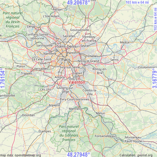
Valenton GPS coordinates[2]
48° 44' 42.972" North, 2° 27' 52.812" East
| Map corner | latitude | longitude |
|---|---|---|
| Upper-left | 49.20678°, | 1.76154° |
| Center: | 48.74527°, | 2.46467° |
| Lower-right: | 48.27948°, | 3.16779° |
| Map W x H: | 103.1×103.1 km | = 64.1×64.1mi |
| max Lat: | 51.07786° ⇑25.8% North |
| Valenton: | 48.74527° |
| min Lat: | ⇓74.2% South 41.3874° |
| min Long | Valenton | max Long |
| -5.08615° | 2.46467° | 9.52242° |
| W 50%⇐ | ⇒50% E |
Elevation
Elevation of Valenton is 52 m = 171 ft, and this is 141.7 m = 465 ft below average elevation for this country.
| Max E: |
2333 m = 7654 ft | 81.1% |
| Avg. | 193.7 m = 635 ft | |
| Valenton | 52 m = 171 ft | |
Min E: |
-1 m = -3 ft | 18.9% |
See also: France elevation on elevation.city.
Geographical zone
Valenton is located in North temperate zone (between Tropic of Cancer and the Arctic Circle). Distance of this North polar circle is 1981.2 km =1231.1 mi to North.| Distance of | km | miles | from Valenton |
|---|---|---|---|
| North Pole | 4587.1 | 2850.3 | to North |
| Arctic Circle | 1981.2 | 1231.1 | to North |
| Tropic Cancer | 2814 | 1748.5 | to South |
| Equator | 5420 | 3367.8 | to South |


Nearby cities:
15 places around Valenton: (largest is in red/bold)
• Ablon-sur-Seine
3.4 km =2.1 mi,  234°
234°
• Boissy-Saint-Léger
3.5 km =2.2 mi,  78°
78°
• Bonneuil-sur-Marne
2.9 km =1.8 mi,  21°
21°
• Choisy-le-Roi
4.2 km =2.6 mi,  307°
307°
• Crosne
2.9 km =1.8 mi,  190°
190°
• Créteil
5.3 km =3.3 mi,  0°
0°
• Limeil-Brévannes
1.6 km =1 mi,  91°
91°
• Montgeron
4.6 km =2.9 mi, 193°
• Orly
5.3 km =3.3 mi,  273°
273°
• Saint-Maur-des-Fossés
5.8 km =3.6 mi, 21°
• Sucy-en-Brie
5.8 km =3.6 mi,  63°
63°
• Thiais
5.5 km =3.4 mi,  293°
293°
• Villeneuve-Saint-Georges
1.8 km =1.1 mi,  217°
217°
• Villeneuve-le-Roi
4.8 km =3 mi,  258°
258°
• Yerres
3.7 km =2.3 mi,  145°
145°
Sources, notices
• [Note1] Compared only with cities in France existing in our database
• [Src1] Map data: © OpenStreetMap contributors (CC-BY-SA)
• [Src2] Other city data from geonames.org with taken over terms of usage.
• [Src3] Geographical zone / Annual Mean Temperature by Robert A. Rohde @ Wikipedia
