Mandres-les-Roses geodata
Mandres-les-Roses (Île-de-France) is a populated place; located in France in Europe/Paris (GMT+2) time zone. With population of 4,243 people, there are 2319 cities with bigger population in this country. Compared to other cities in France, 73.3% of cities are located further ↓South; 51.3% of cities are located further ←West and 63.2% of cities have higher elevation than Mandres-les-Roses. Note1
Administrative division(s):
- Level 1: Île-de-France
- Level 2: Val-de-Marne
- Level 3: Arrondissement de Créteil
- Level 4: Mandres-les-Roses


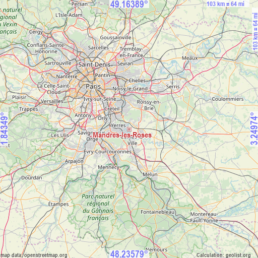
Mandres-les-Roses GPS coordinates[2]
48° 42' 7.128" North, 2° 32' 47.832" East
| Map corner | latitude | longitude |
|---|---|---|
| Upper-left | 49.16389°, | 1.84349° |
| Center: | 48.70198°, | 2.54662° |
| Lower-right: | 48.23579°, | 3.24974° |
| Map W x H: | 103.2×103.2 km | = 64.1×64.1mi |
| max Lat: | 51.07786° ⇑26.7% North |
| Mandres-les-Roses: | 48.70198° |
| min Lat: | ⇓73.3% South 41.3874° |
| min Long | Mandres-les-Ros | max Long |
| -5.08615° | 2.54662° | 9.52242° |
| W 51.3%⇐ | ⇒48.7% E |
Elevation
Elevation of Mandres-les-Roses is 94 m = 308 ft, and this is 99.7 m = 327 ft below average elevation for this country.
| Max E: |
2333 m = 7654 ft | 63.2% |
| Avg. | 193.7 m = 635 ft | |
| Mandres-les-Roses | 94 m = 308 ft | |
Min E: |
-1 m = -3 ft | 36.8% |
See also: France elevation on elevation.city.
Geographical zone
Mandres-les-Roses is located in North temperate zone (between Tropic of Cancer and the Arctic Circle). Distance of this North polar circle is 1986 km =1234 mi to North.| Distance of | km | miles | from Mandres-les-Roses |
|---|---|---|---|
| North Pole | 4591.9 | 2853.3 | to North |
| Arctic Circle | 1986 | 1234 | to North |
| Tropic Cancer | 2809.2 | 1745.6 | to South |
| Equator | 5415.2 | 3364.8 | to South |


Nearby cities:
15 places around Mandres-les-Roses: (largest is in red/bold)
• Boissy-Saint-Léger
6.1 km =3.8 mi,  335°
335°
• Boussy-Saint-Antoine
1.7 km =1.1 mi,  223°
223°
• Brie-Comte-Robert
4.8 km =3 mi,  102°
102°
• Brunoy
4.1 km =2.5 mi,  257°
257°
• Combs-la-Ville
4.4 km =2.7 mi,  157°
157°
• Limeil-Brévannes
6.5 km =4 mi,  317°
317°
• Lésigny
6.8 km =4.2 mi,  47°
47°
• Périgny
0.9 km =0.6 mi,  133°
133°
• Quincy-sous-Sénart
3.4 km =2.1 mi,  195°
195°
• Santeny
3.4 km =2.1 mi,  34°
34°
• Servon
3.4 km =2.1 mi,  61°
61°
• Varennes-Jarcy
2.8 km =1.7 mi, 156°
• Villecresnes
2.1 km =1.3 mi,  345°
345°
• Yerres
4.3 km =2.7 mi,  294°
294°
• Épinay-sous-Sénart
2.9 km =1.8 mi,  241°
241°
Sources, notices
• [Note1] Compared only with cities in France existing in our database
• [Src1] Map data: © OpenStreetMap contributors (CC-BY-SA)
• [Src2] Other city data from geonames.org with taken over terms of usage.
• [Src3] Geographical zone / Annual Mean Temperature by Robert A. Rohde @ Wikipedia
