Herzeele geodata
Herzeele (Hauts-de-France) is a populated place; located in France in Europe/Paris (GMT+2) time zone. With population of 1,328 people, there are 6901 cities with bigger population in this country. Compared to other cities in France, 99.6% of cities are located further ↓South; 51.1% of cities are located further ←West and 96.7% of cities have higher elevation than Herzeele. Note1
Administrative division(s):
- Level 1: Hauts-de-France
- Level 2: Nord
- Level 3: Arrondissement de Dunkerque
- Level 4: Herzeele


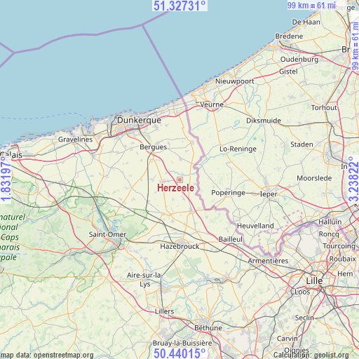
Herzeele GPS coordinates[2]
50° 53' 9.024" North, 2° 32' 6.36" East
| Map corner | latitude | longitude |
|---|---|---|
| Upper-left | 51.32731°, | 1.83197° |
| Center: | 50.88584°, | 2.5351° |
| Lower-right: | 50.44015°, | 3.23822° |
| Map W x H: | 98.6×98.6 km | = 61.3×61.3mi |
| max Lat: | 51.07786° ⇑0.4% North |
| Herzeele: | 50.88584° |
| min Lat: | ⇓99.6% South 41.3874° |
| min Long | Herzeele | max Long |
| -5.08615° | 2.5351° | 9.52242° |
| W 51.1%⇐ | ⇒48.9% E |
Elevation
Elevation of Herzeele is 12 m = 39 ft, and this is 181.7 m = 596 ft below average elevation for this country.
| Max E: |
2333 m = 7654 ft | 96.7% |
| Avg. | 193.7 m = 635 ft | |
| Herzeele | 12 m = 39 ft | |
Min E: |
-1 m = -3 ft | 3.3% |
See also: France elevation on elevation.city.
Geographical zone
Herzeele is located in North temperate zone (between Tropic of Cancer and the Arctic Circle). Distance of this North polar circle is 1743.2 km =1083.2 mi to North.| Distance of | km | miles | from Herzeele |
|---|---|---|---|
| North Pole | 4349.1 | 2702.4 | to North |
| Arctic Circle | 1743.2 | 1083.2 | to North |
| Tropic Cancer | 3052.1 | 1896.5 | to South |
| Equator | 5658 | 3515.7 | to South |


Nearby cities:
15 places around Herzeele: (largest is in red/bold)
• Bambecque
2 km =1.2 mi,  28°
28°
• Esquelbecq
7.2 km =4.5 mi,  270°
270°
• Houtkerque
4.4 km =2.7 mi,  102°
102°
• Killem
8.2 km =5.1 mi,  12°
12°
• Ledringhem
7.4 km =4.6 mi,  242°
242°
• Oudezeele
5.6 km =3.5 mi,  198°
198°
• Quaëdypre
7.9 km =4.9 mi,  314°
314°
• Rexpoëde
5.9 km =3.7 mi,  2°
2°
• Socx
9.5 km =5.9 mi, 305°
• Steenvoorde
9 km =5.6 mi,  158°
158°
• Terdeghem
9.7 km =6 mi,  178°
178°
• West-Cappel
5.3 km =3.3 mi,  337°
337°
• Winnezeele
5.1 km =3.2 mi,  167°
167°
• Wormhout
4.7 km =2.9 mi,  263°
263°
• Zegerscappel
9.5 km =5.9 mi, 268°
Sources, notices
• [Note1] Compared only with cities in France existing in our database
• [Src1] Map data: © OpenStreetMap contributors (CC-BY-SA)
• [Src2] Other city data from geonames.org with taken over terms of usage.
• [Src3] Geographical zone / Annual Mean Temperature by Robert A. Rohde @ Wikipedia
