Houtkerque geodata
Houtkerque (Hauts-de-France) is a populated place; located in France in Europe/Paris (GMT+2) time zone. With population of 791 people, there are 10703 cities with bigger population in this country. Compared to other cities in France, 99.6% of cities are located further ↓South; 52% of cities are located further ←West and 95.4% of cities have higher elevation than Houtkerque. Note1
Administrative division(s):
- Level 1: Hauts-de-France
- Level 2: Nord
- Level 3: Arrondissement de Dunkerque
- Level 4: Houtkerque


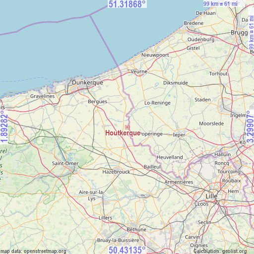
Houtkerque GPS coordinates[2]
50° 52' 37.668" North, 2° 35' 45.384" East
| Map corner | latitude | longitude |
|---|---|---|
| Upper-left | 51.31868°, | 1.89282° |
| Center: | 50.87713°, | 2.59594° |
| Lower-right: | 50.43135°, | 3.29907° |
| Map W x H: | 98.7×98.7 km | = 61.3×61.3mi |
| max Lat: | 51.07786° ⇑0.4% North |
| Houtkerque: | 50.87713° |
| min Lat: | ⇓99.6% South 41.3874° |
| min Long | Houtkerque | max Long |
| -5.08615° | 2.59594° | 9.52242° |
| W 52%⇐ | ⇒48% E |
Elevation
Elevation of Houtkerque is 16 m = 52 ft, and this is 177.7 m = 583 ft below average elevation for this country.
| Max E: |
2333 m = 7654 ft | 95.4% |
| Avg. | 193.7 m = 635 ft | |
| Houtkerque | 16 m = 52 ft | |
Min E: |
-1 m = -3 ft | 4.6% |
See also: France elevation on elevation.city.
Geographical zone
Houtkerque is located in North temperate zone (between Tropic of Cancer and the Arctic Circle). Distance of this North polar circle is 1744.2 km =1083.8 mi to North.| Distance of | km | miles | from Houtkerque |
|---|---|---|---|
| North Pole | 4350.1 | 2703 | to North |
| Arctic Circle | 1744.2 | 1083.8 | to North |
| Tropic Cancer | 3051.1 | 1895.9 | to South |
| Equator | 5657 | 3515.1 | to South |


Nearby cities:
15 places around Houtkerque: (largest is in red/bold)
• Bambecque
4.3 km =2.7 mi,  309°
309°
• Boeschepe
11.3 km =7 mi,  139°
139°
• Eecke
11 km =6.8 mi,  179°
179°
• Godewaersvelde
9.9 km =6.2 mi,  159°
159°
• Herzeele
4.4 km =2.7 mi,  282°
282°
• Hondschoote
11.2 km =7 mi,  355°
355°
• Killem
9.3 km =5.8 mi,  344°
344°
• Ledringhem
11.1 km =6.9 mi,  257°
257°
• Oudezeele
7.4 km =4.6 mi,  234°
234°
• Rexpoëde
8 km =5 mi,  330°
330°
• Steenvoorde
7.5 km =4.7 mi,  187°
187°
• Terdeghem
9.6 km =6 mi,  204°
204°
• West-Cappel
8.6 km =5.3 mi, 312°
• Winnezeele
5.1 km =3.2 mi,  218°
218°
• Wormhout
8.9 km =5.5 mi,  272°
272°
Sources, notices
• [Note1] Compared only with cities in France existing in our database
• [Src1] Map data: © OpenStreetMap contributors (CC-BY-SA)
• [Src2] Other city data from geonames.org with taken over terms of usage.
• [Src3] Geographical zone / Annual Mean Temperature by Robert A. Rohde @ Wikipedia
