Mably geodata
Mably (Auvergne-Rhône-Alpes) is a populated place; located in France in Europe/Paris (GMT+2) time zone. With population of 7,830 people, there are 1241 cities with bigger population in this country. Compared to other cities in France, 65.5% of cities are located further ↑North; 68.4% of cities are located further ←West and 79.1% of cities have lower elevation than Mably. Note1
Administrative division(s):
- Level 1: Auvergne-Rhône-Alpes
- Level 2: Département de la Loire
- Level 3: Arrondissement de Roanne
- Level 4: Mably


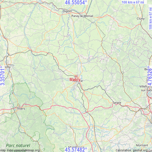
Mably GPS coordinates[2]
46° 3' 53.424" North, 4° 3' 36.504" East
| Map corner | latitude | longitude |
|---|---|---|
| Upper-left | 46.55054°, | 3.35701° |
| Center: | 46.06484°, | 4.06014° |
| Lower-right: | 45.57482°, | 4.76326° |
| Map W x H: | 108.5×108.5 km | = 67.4×67.4mi |
| max Lat: | 51.07786° ⇑65.5% North |
| Mably: | 46.06484° |
| min Lat: | ⇓34.5% South 41.3874° |
| min Long | Mably | max Long |
| -5.08615° | 4.06014° | 9.52242° |
| W 68.4%⇐ | ⇒31.6% E |
Elevation
Elevation of Mably is 281 m = 922 ft, and this is 87.3 m = 286 ft above average elevation for this country.
| Max E: |
2333 m = 7654 ft | 20.9% |
| Mably | 281 m 922 ft | |
| Avg. | 193.7 m = 635 ft | |
Min E: |
-1 m = -3 ft | 79.1% |
See also: France elevation on elevation.city.
Geographical zone
Mably is located in North temperate zone (between Tropic of Cancer and the Arctic Circle). Distance of this North polar circle is 2279.2 km =1416.2 mi to North.| Distance of | km | miles | from Mably |
|---|---|---|---|
| North Pole | 4885.1 | 3035.5 | to North |
| Arctic Circle | 2279.2 | 1416.2 | to North |
| Tropic Cancer | 2516 | 1563.4 | to South |
| Equator | 5121.9 | 3182.6 | to South |


Nearby cities:
15 places around Mably: (largest is in red/bold)
• Commelle
7.1 km =4.4 mi,  181°
181°
• Le Coteau
5.7 km =3.5 mi,  153°
153°
• Noailly
8.7 km =5.4 mi,  335°
335°
• Ouches
7.8 km =4.8 mi,  225°
225°
• Parigny
8.7 km =5.4 mi,  158°
158°
• Perreux
5.8 km =3.6 mi,  118°
118°
• Pouilly-les-Nonains
6.4 km =4 mi,  249°
249°
• Riorges
2.7 km =1.7 mi,  210°
210°
• Roanne
3.2 km =2 mi,  169°
169°
• Saint-Germain-Lespinasse
8.5 km =5.3 mi,  300°
300°
• Saint-Léger-sur-Roanne
5.5 km =3.4 mi,  242°
242°
• Saint-Romain-la-Motte
5.7 km =3.5 mi,  289°
289°
• Saint-Vincent-de-Boisset
8 km =5 mi,  143°
143°
• Villerest
8 km =5 mi,  194°
194°
• Vougy
6.2 km =3.9 mi,  45°
45°
Sources, notices
• [Note1] Compared only with cities in France existing in our database
• [Src1] Map data: © OpenStreetMap contributors (CC-BY-SA)
• [Src2] Other city data from geonames.org with taken over terms of usage.
• [Src3] Geographical zone / Annual Mean Temperature by Robert A. Rohde @ Wikipedia
