Perreux geodata
Perreux (Auvergne-Rhône-Alpes) is a populated place; located in France in Europe/Paris (GMT+2) time zone. With population of 2,444 people, there are 3964 cities with bigger population in this country. Compared to other cities in France, 65.8% of cities are located further ↑North; 69% of cities are located further ←West and 82.5% of cities have lower elevation than Perreux. Note1
Administrative division(s):
- Level 1: Auvergne-Rhône-Alpes
- Level 2: Département de la Loire
- Level 3: Arrondissement de Roanne
- Level 4: Perreux


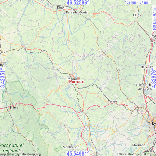
Perreux GPS coordinates[2]
46° 2' 24.144" North, 4° 7' 35.868" East
| Map corner | latitude | longitude |
|---|---|---|
| Upper-left | 46.52596°, | 3.42351° |
| Center: | 46.04004°, | 4.12663° |
| Lower-right: | 45.54981°, | 4.82976° |
| Map W x H: | 108.5×108.5 km | = 67.4×67.4mi |
| max Lat: | 51.07786° ⇑65.8% North |
| Perreux: | 46.04004° |
| min Lat: | ⇓34.2% South 41.3874° |
| min Long | Perreux | max Long |
| -5.08615° | 4.12663° | 9.52242° |
| W 69%⇐ | ⇒31% E |
Elevation
Elevation of Perreux is 316 m = 1037 ft, and this is 122.3 m = 401 ft above average elevation for this country.
| Max E: |
2333 m = 7654 ft | 17.5% |
| Perreux | 316 m 1037 ft | |
| Avg. | 193.7 m = 635 ft | |
Min E: |
-1 m = -3 ft | 82.5% |
See also: France elevation on elevation.city.
Geographical zone
Perreux is located in North temperate zone (between Tropic of Cancer and the Arctic Circle). Distance of this North polar circle is 2282 km =1418 mi to North.| Distance of | km | miles | from Perreux |
|---|---|---|---|
| North Pole | 4887.9 | 3037.2 | to North |
| Arctic Circle | 2282 | 1418 | to North |
| Tropic Cancer | 2513.3 | 1561.7 | to South |
| Equator | 5119.2 | 3180.9 | to South |


Nearby cities:
15 places around Perreux: (largest is in red/bold)
• Commelle
6.9 km =4.3 mi,  230°
230°
• Coutouvre
7.1 km =4.4 mi,  58°
58°
• Le Coteau
3.5 km =2.2 mi, 228°
• Mably
5.8 km =3.6 mi,  298°
298°
• Nandax
7.1 km =4.4 mi,  25°
25°
• Notre-Dame-de-Boisset
4.4 km =2.7 mi,  173°
173°
• Parigny
5.7 km =3.5 mi,  199°
199°
• Pradines
6.1 km =3.8 mi,  142°
142°
• Riorges
6.5 km =4 mi,  273°
273°
• Roanne
4.5 km =2.8 mi,  264°
264°
• Régny
8.8 km =5.5 mi,  128°
128°
• Saint-Cyr-de-Favières
8.6 km =5.3 mi, 199°
• Saint-Vincent-de-Boisset
3.6 km =2.2 mi,  185°
185°
• Villerest
8.7 km =5.4 mi,  235°
235°
• Vougy
7.2 km =4.5 mi,  354°
354°
Sources, notices
• [Note1] Compared only with cities in France existing in our database
• [Src1] Map data: © OpenStreetMap contributors (CC-BY-SA)
• [Src2] Other city data from geonames.org with taken over terms of usage.
• [Src3] Geographical zone / Annual Mean Temperature by Robert A. Rohde @ Wikipedia
