Viré geodata
Viré (Bourgogne-Franche-Comté) is a populated place; located in France in Europe/Paris (GMT+2) time zone. With population of 982 people, there are 8971 cities with bigger population in this country. Compared to other cities in France, 60.5% of cities are located further ↑North; 75.7% of cities are located further ←West and 69.4% of cities have lower elevation than Viré. Note1
Administrative division(s):
- Level 1: Bourgogne-Franche-Comté
- Level 2: Département de Saône-et-Loire
- Level 3: Arrondissement de Mâcon
- Level 4: Viré


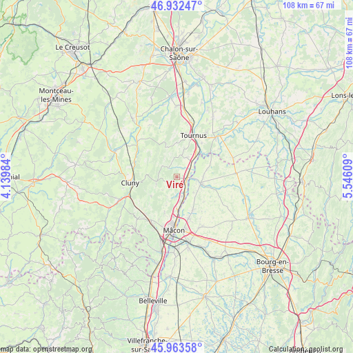
Viré GPS coordinates[2]
46° 27' 0.648" North, 4° 50' 34.656" East
| Map corner | latitude | longitude |
|---|---|---|
| Upper-left | 46.93247°, | 4.13984° |
| Center: | 46.45018°, | 4.84296° |
| Lower-right: | 45.96358°, | 5.54609° |
| Map W x H: | 107.7×107.7 km | = 66.9×66.9mi |
| max Lat: | 51.07786° ⇑60.5% North |
| Viré: | 46.45018° |
| min Lat: | ⇓39.5% South 41.3874° |
| min Long | Viré | max Long |
| -5.08615° | 4.84296° | 9.52242° |
| W 75.7%⇐ | ⇒24.3% E |
Elevation
Elevation of Viré is 216 m = 709 ft, and this is 22.3 m = 73 ft above average elevation for this country.
| Max E: |
2333 m = 7654 ft | 30.6% |
| Viré | 216 m 709 ft | |
| Avg. | 193.7 m = 635 ft | |
Min E: |
-1 m = -3 ft | 69.4% |
See also: France elevation on elevation.city.
Geographical zone
Viré is located in North temperate zone (between Tropic of Cancer and the Arctic Circle). Distance of this North polar circle is 2236.4 km =1389.6 mi to North.| Distance of | km | miles | from Viré |
|---|---|---|---|
| North Pole | 4842.3 | 3008.9 | to North |
| Arctic Circle | 2236.4 | 1389.6 | to North |
| Tropic Cancer | 2558.9 | 1590 | to South |
| Equator | 5164.8 | 3209.3 | to South |


Nearby cities:
15 places around Viré: (largest is in red/bold)
• Azé
6.6 km =4.1 mi,  251°
251°
• Clessé
4.4 km =2.7 mi,  208°
208°
• Gorrevod
8.6 km =5.3 mi,  113°
113°
• Laizé
6.8 km =4.2 mi,  204°
204°
• Lugny
3.5 km =2.2 mi,  314°
314°
• Montbellet
3.7 km =2.3 mi,  39°
39°
• Ozan
8.6 km =5.3 mi,  140°
140°
• Plottes
9.1 km =5.7 mi,  15°
15°
• Pont-de-Vaux
8 km =5 mi,  103°
103°
• Reyssouze
6.2 km =3.9 mi, 105°
• Saint-Albain
3.5 km =2.2 mi,  134°
134°
• Saint-Gengoux-de-Scissé
5.4 km =3.4 mi,  286°
286°
• Saint-Martin-Belle-Roche
7.5 km =4.7 mi,  172°
172°
• Senozan
6.2 km =3.9 mi, 165°
• Uchizy
6.8 km =4.2 mi,  28°
28°
Sources, notices
• [Note1] Compared only with cities in France existing in our database
• [Src1] Map data: © OpenStreetMap contributors (CC-BY-SA)
• [Src2] Other city data from geonames.org with taken over terms of usage.
• [Src3] Geographical zone / Annual Mean Temperature by Robert A. Rohde @ Wikipedia
