Pont-de-Vaux geodata
Pont-de-Vaux (Auvergne-Rhône-Alpes) is a populated place; located in France in Europe/Paris (GMT+2) time zone. With population of 2,055 people, there are 4672 cities with bigger population in this country. Compared to other cities in France, 60.7% of cities are located further ↑North; 77% of cities are located further ←West and 63.8% of cities have lower elevation than Pont-de-Vaux. Note1
Administrative division(s):
- Level 1: Auvergne-Rhône-Alpes
- Level 2: Département de l'Ain
- Level 3: Arrondissement de Bourg-en-Bresse
- Level 4: Pont-de-Vaux


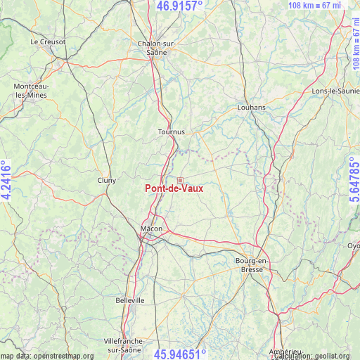
Pont-de-Vaux GPS coordinates[2]
46° 25' 59.736" North, 4° 56' 41.028" East
| Map corner | latitude | longitude |
|---|---|---|
| Upper-left | 46.9157°, | 4.2416° |
| Center: | 46.43326°, | 4.94473° |
| Lower-right: | 45.94651°, | 5.64785° |
| Map W x H: | 107.8×107.8 km | = 67×67mi |
| max Lat: | 51.07786° ⇑60.7% North |
| Pont-de-Vaux: | 46.43326° |
| min Lat: | ⇓39.3% South 41.3874° |
| min Long | Pont-de-Vaux | max Long |
| -5.08615° | 4.94473° | 9.52242° |
| W 77%⇐ | ⇒23% E |
Elevation
Elevation of Pont-de-Vaux is 188 m = 617 ft, and this is 5.7 m = 19 ft below average elevation for this country.
| Max E: |
2333 m = 7654 ft | 36.2% |
| Avg. | 193.7 m = 635 ft | |
| Pont-de-Vaux | 188 m = 617 ft | |
Min E: |
-1 m = -3 ft | 63.8% |
See also: France elevation on elevation.city.
Geographical zone
Pont-de-Vaux is located in North temperate zone (between Tropic of Cancer and the Arctic Circle). Distance of this North polar circle is 2238.3 km =1390.8 mi to North.| Distance of | km | miles | from Pont-de-Vaux |
|---|---|---|---|
| North Pole | 4844.2 | 3010 | to North |
| Arctic Circle | 2238.3 | 1390.8 | to North |
| Tropic Cancer | 2557 | 1588.8 | to South |
| Equator | 5162.9 | 3208.1 | to South |


Nearby cities:
15 places around Pont-de-Vaux: (largest is in red/bold)
• Chavannes-sur-Reyssouze
4 km =2.5 mi,  93°
93°
• Chevroux
5.7 km =3.5 mi,  173°
173°
• Gorrevod
1.6 km =1 mi,  178°
178°
• Manziat
8.5 km =5.3 mi,  200°
200°
• Montbellet
7.2 km =4.5 mi,  310°
310°
• Ozan
5.2 km =3.2 mi,  205°
205°
• Reyssouze
1.9 km =1.2 mi,  275°
275°
• Saint-Albain
5.3 km =3.3 mi,  263°
263°
• Saint-Bénigne
2.2 km =1.4 mi,  72°
72°
• Saint-Jean-sur-Reyssouze
9.9 km =6.2 mi,  114°
114°
• Saint-Martin-Belle-Roche
8.8 km =5.5 mi,  230°
230°
• Senozan
7.5 km =4.7 mi,  236°
236°
• Sermoyer
7.8 km =4.8 mi,  19°
19°
• Uchizy
9 km =5.6 mi,  329°
329°
• Viré
8 km =5 mi, 283°
Sources, notices
• [Note1] Compared only with cities in France existing in our database
• [Src1] Map data: © OpenStreetMap contributors (CC-BY-SA)
• [Src2] Other city data from geonames.org with taken over terms of usage.
• [Src3] Geographical zone / Annual Mean Temperature by Robert A. Rohde @ Wikipedia
