Plottes geodata
Plottes (Bourgogne-Franche-Comté) is a populated place; located in France in Europe/Paris (GMT+2) time zone. With population of 595 people, there are 13406 cities with bigger population in this country. Compared to other cities in France, 59.9% of cities are located further ↑North; 76.1% of cities are located further ←West and 76.1% of cities have lower elevation than Plottes. Note1
Administrative division(s):
- Level 1: Bourgogne-Franche-Comté
- Level 2: Département de Saône-et-Loire
- Level 3: Arrondissement de Mâcon
- Level 4: Plottes


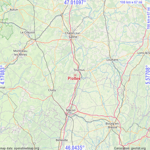
Plottes GPS coordinates[2]
46° 31' 45.804" North, 4° 52' 26.22" East
| Map corner | latitude | longitude |
|---|---|---|
| Upper-left | 47.01097°, | 4.17083° |
| Center: | 46.52939°, | 4.87395° |
| Lower-right: | 46.0435°, | 5.57708° |
| Map W x H: | 107.6×107.6 km | = 66.9×66.9mi |
| max Lat: | 51.07786° ⇑59.9% North |
| Plottes: | 46.52939° |
| min Lat: | ⇓40.1% South 41.3874° |
| min Long | Plottes | max Long |
| -5.08615° | 4.87395° | 9.52242° |
| W 76.1%⇐ | ⇒23.9% E |
Elevation
Elevation of Plottes is 257 m = 843 ft, and this is 63.3 m = 208 ft above average elevation for this country.
| Max E: |
2333 m = 7654 ft | 23.9% |
| Plottes | 257 m 843 ft | |
| Avg. | 193.7 m = 635 ft | |
Min E: |
-1 m = -3 ft | 76.1% |
See also: France elevation on elevation.city.
Geographical zone
Plottes is located in North temperate zone (between Tropic of Cancer and the Arctic Circle). Distance of this North polar circle is 2227.6 km =1384.2 mi to North.| Distance of | km | miles | from Plottes |
|---|---|---|---|
| North Pole | 4833.5 | 3003.4 | to North |
| Arctic Circle | 2227.6 | 1384.2 | to North |
| Tropic Cancer | 2567.7 | 1595.5 | to South |
| Equator | 5173.6 | 3214.7 | to South |


Nearby cities:
15 places around Plottes: (largest is in red/bold)
• Boyer
7 km =4.3 mi,  6°
6°
• Cuisery
10 km =6.2 mi,  72°
72°
• Lacrost
5.5 km =3.4 mi,  54°
54°
• Lugny
8 km =5 mi,  217°
217°
• Montbellet
5.9 km =3.7 mi,  180°
180°
• Nanton
11 km =6.8 mi,  336°
336°
• Pont-de-Vaux
12 km =7.5 mi,  153°
153°
• Préty
5.4 km =3.4 mi, 74°
• Reyssouze
11.1 km =6.9 mi,  161°
161°
• Saint-Albain
11.3 km =7 mi, 179°
• Saint-Gengoux-de-Scissé
10.5 km =6.5 mi,  226°
226°
• Sermoyer
8.7 km =5.4 mi,  112°
112°
• Tournus
4.9 km =3 mi,  29°
29°
• Uchizy
3 km =1.9 mi, 162°
• Viré
9.1 km =5.7 mi,  195°
195°
Sources, notices
• [Note1] Compared only with cities in France existing in our database
• [Src1] Map data: © OpenStreetMap contributors (CC-BY-SA)
• [Src2] Other city data from geonames.org with taken over terms of usage.
• [Src3] Geographical zone / Annual Mean Temperature by Robert A. Rohde @ Wikipedia
