Saint-Albain geodata
Saint-Albain (Bourgogne-Franche-Comté) is a populated place; located in France in Europe/Paris (GMT+2) time zone. With population of 509 people, there are 15057 cities with bigger population in this country. Compared to other cities in France, 60.8% of cities are located further ↑North; 76.2% of cities are located further ←West and 61% of cities have lower elevation than Saint-Albain. Note1
Administrative division(s):
- Level 1: Bourgogne-Franche-Comté
- Level 2: Département de Saône-et-Loire
- Level 3: Arrondissement de Mâcon
- Level 4: Saint-Albain


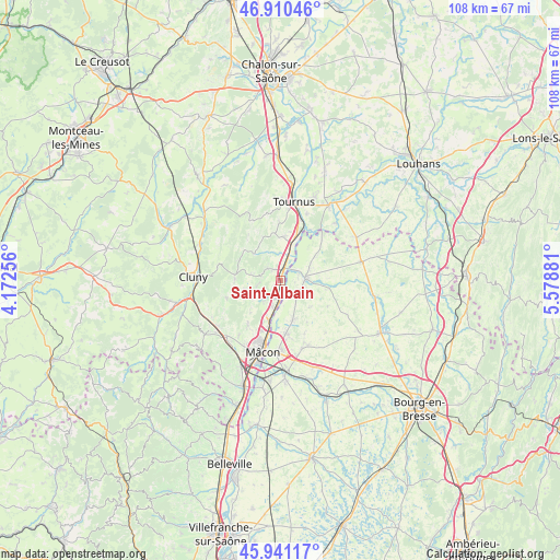
Saint-Albain GPS coordinates[2]
46° 25' 40.692" North, 4° 52' 32.484" East
| Map corner | latitude | longitude |
|---|---|---|
| Upper-left | 46.91046°, | 4.17256° |
| Center: | 46.42797°, | 4.87569° |
| Lower-right: | 45.94117°, | 5.57881° |
| Map W x H: | 107.8×107.8 km | = 67×67mi |
| max Lat: | 51.07786° ⇑60.8% North |
| Saint-Albain: | 46.42797° |
| min Lat: | ⇓39.2% South 41.3874° |
| min Long | Saint-Albain | max Long |
| -5.08615° | 4.87569° | 9.52242° |
| W 76.2%⇐ | ⇒23.8% E |
Elevation
Elevation of Saint-Albain is 175 m = 574 ft, and this is 18.7 m = 61 ft below average elevation for this country.
| Max E: |
2333 m = 7654 ft | 39% |
| Avg. | 193.7 m = 635 ft | |
| Saint-Albain | 175 m = 574 ft | |
Min E: |
-1 m = -3 ft | 61% |
See also: France elevation on elevation.city.
Geographical zone
Saint-Albain is located in North temperate zone (between Tropic of Cancer and the Arctic Circle). Distance of this North polar circle is 2238.9 km =1391.2 mi to North.| Distance of | km | miles | from Saint-Albain |
|---|---|---|---|
| North Pole | 4844.8 | 3010.4 | to North |
| Arctic Circle | 2238.9 | 1391.2 | to North |
| Tropic Cancer | 2556.4 | 1588.5 | to South |
| Equator | 5162.3 | 3207.7 | to South |


Nearby cities:
15 places around Saint-Albain: (largest is in red/bold)
• Chevroux
7.8 km =4.8 mi,  130°
130°
• Clessé
4.8 km =3 mi,  253°
253°
• Gorrevod
5.4 km =3.4 mi,  100°
100°
• Laizé
6.5 km =4 mi,  235°
235°
• Lugny
7 km =4.3 mi,  314°
314°
• Manziat
7.8 km =4.8 mi,  162°
162°
• Montbellet
5.3 km =3.3 mi,  358°
358°
• Ozan
5.1 km =3.2 mi,  143°
143°
• Pont-de-Vaux
5.3 km =3.3 mi,  83°
83°
• Reyssouze
3.5 km =2.2 mi, 77°
• Saint-Bénigne
7.5 km =4.7 mi, 80°
• Saint-Martin-Belle-Roche
5.2 km =3.2 mi,  197°
197°
• Senozan
3.7 km =2.3 mi, 195°
• Uchizy
8.4 km =5.2 mi,  5°
5°
• Viré
3.5 km =2.2 mi, 314°
Sources, notices
• [Note1] Compared only with cities in France existing in our database
• [Src1] Map data: © OpenStreetMap contributors (CC-BY-SA)
• [Src2] Other city data from geonames.org with taken over terms of usage.
• [Src3] Geographical zone / Annual Mean Temperature by Robert A. Rohde @ Wikipedia
