Montbellet geodata
Montbellet (Bourgogne-Franche-Comté) is a populated place; located in France in Europe/Paris (GMT+2) time zone. With population of 668 people, there are 12251 cities with bigger population in this country. Compared to other cities in France, 60.3% of cities are located further ↑North; 76.1% of cities are located further ←West and 66.8% of cities have lower elevation than Montbellet. Note1
Administrative division(s):
- Level 1: Bourgogne-Franche-Comté
- Level 2: Département de Saône-et-Loire
- Level 3: Arrondissement de Mâcon
- Level 4: Montbellet


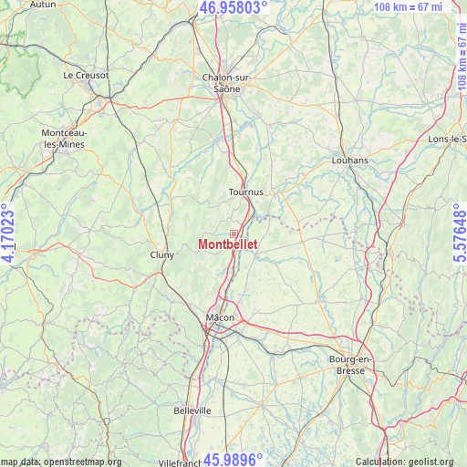
Montbellet GPS coordinates[2]
46° 28' 33.492" North, 4° 52' 24.096" East
| Map corner | latitude | longitude |
|---|---|---|
| Upper-left | 46.95803°, | 4.17023° |
| Center: | 46.47597°, | 4.87336° |
| Lower-right: | 45.9896°, | 5.57648° |
| Map W x H: | 107.7×107.7 km | = 66.9×66.9mi |
| max Lat: | 51.07786° ⇑60.3% North |
| Montbellet: | 46.47597° |
| min Lat: | ⇓39.7% South 41.3874° |
| min Long | Montbellet | max Long |
| -5.08615° | 4.87336° | 9.52242° |
| W 76.1%⇐ | ⇒23.9% E |
Elevation
Elevation of Montbellet is 203 m = 666 ft, and this is 9.3 m = 31 ft above average elevation for this country.
| Max E: |
2333 m = 7654 ft | 33.2% |
| Montbellet | 203 m 666 ft | |
| Avg. | 193.7 m = 635 ft | |
Min E: |
-1 m = -3 ft | 66.8% |
See also: France elevation on elevation.city.
Geographical zone
Montbellet is located in North temperate zone (between Tropic of Cancer and the Arctic Circle). Distance of this North polar circle is 2233.5 km =1387.8 mi to North.| Distance of | km | miles | from Montbellet |
|---|---|---|---|
| North Pole | 4839.4 | 3007.1 | to North |
| Arctic Circle | 2233.5 | 1387.8 | to North |
| Tropic Cancer | 2561.7 | 1591.8 | to South |
| Equator | 5167.6 | 3211 | to South |


Nearby cities:
15 places around Montbellet: (largest is in red/bold)
• Azé
9.9 km =6.2 mi,  240°
240°
• Clessé
8 km =5 mi,  213°
213°
• Gorrevod
8.4 km =5.2 mi,  139°
139°
• Lugny
4.9 km =3 mi,  265°
265°
• Plottes
5.9 km =3.7 mi,  0°
0°
• Pont-de-Vaux
7.2 km =4.5 mi,  130°
130°
• Préty
9.1 km =5.7 mi,  35°
35°
• Reyssouze
5.8 km =3.6 mi, 141°
• Saint-Albain
5.3 km =3.3 mi,  178°
178°
• Saint-Bénigne
8.6 km =5.3 mi,  118°
118°
• Saint-Gengoux-de-Scissé
7.6 km =4.7 mi,  259°
259°
• Senozan
8.9 km =5.5 mi,  185°
185°
• Sermoyer
8.5 km =5.3 mi,  72°
72°
• Uchizy
3.2 km =2 mi,  17°
17°
• Viré
3.7 km =2.3 mi,  219°
219°
Sources, notices
• [Note1] Compared only with cities in France existing in our database
• [Src1] Map data: © OpenStreetMap contributors (CC-BY-SA)
• [Src2] Other city data from geonames.org with taken over terms of usage.
• [Src3] Geographical zone / Annual Mean Temperature by Robert A. Rohde @ Wikipedia
