Givenchy-en-Gohelle geodata
Givenchy-en-Gohelle (Hauts-de-France) is a populated place; located in France in Europe/Paris (GMT+2) time zone. With population of 2,114 people, there are 4554 cities with bigger population in this country. Compared to other cities in France, 96.4% of cities are located further ↓South; 54.5% of cities are located further ←West and 67% of cities have higher elevation than Givenchy-en-Gohelle. Note1
Administrative division(s):
- Level 1: Hauts-de-France
- Level 2: Pas-de-Calais
- Level 3: Arrondissement de Lens
- Level 4: Givenchy-en-Gohelle


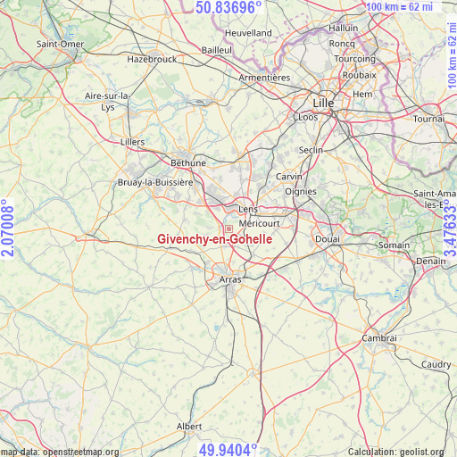
Givenchy-en-Gohelle GPS coordinates[2]
50° 23' 26.88" North, 2° 46' 23.52" East
| Map corner | latitude | longitude |
|---|---|---|
| Upper-left | 50.83696°, | 2.07008° |
| Center: | 50.3908°, | 2.7732° |
| Lower-right: | 49.9404°, | 3.47633° |
| Map W x H: | 99.7×99.7 km | = 62×62mi |
| max Lat: | 51.07786° ⇑3.6% North |
| Givenchy-en-Gohelle: | 50.3908° |
| min Lat: | ⇓96.4% South 41.3874° |
| min Long | Givenchy-en-Goh | max Long |
| -5.08615° | 2.7732° | 9.52242° |
| W 54.5%⇐ | ⇒45.5% E |
Elevation
Elevation of Givenchy-en-Gohelle is 85 m = 279 ft, and this is 108.7 m = 357 ft below average elevation for this country.
| Max E: |
2333 m = 7654 ft | 67% |
| Avg. | 193.7 m = 635 ft | |
| Givenchy-en-Gohelle | 85 m = 279 ft | |
Min E: |
-1 m = -3 ft | 33% |
See also: France elevation on elevation.city.
Geographical zone
Givenchy-en-Gohelle is located in North temperate zone (between Tropic of Cancer and the Arctic Circle). Distance of this North polar circle is 1798.2 km =1117.3 mi to North.| Distance of | km | miles | from Givenchy-en-Gohelle |
|---|---|---|---|
| North Pole | 4404.1 | 2736.6 | to North |
| Arctic Circle | 1798.2 | 1117.3 | to North |
| Tropic Cancer | 2997 | 1862.2 | to South |
| Equator | 5602.9 | 3481.5 | to South |


Nearby cities:
15 places around Givenchy-en-Gohelle: (largest is in red/bold)
• Ablain-Saint-Nazaire
4.6 km =2.9 mi,  273°
273°
• Aix-Noulette
6.2 km =3.9 mi,  308°
308°
• Angres
1.9 km =1.2 mi,  331°
331°
• Avion
4.6 km =2.9 mi,  61°
61°
• Carency
5.1 km =3.2 mi,  254°
254°
• Farbus
5.3 km =3.3 mi,  136°
136°
• Lens
6.1 km =3.8 mi,  39°
39°
• Liévin
3.3 km =2.1 mi,  9°
9°
• Méricourt
6.4 km =4 mi,  79°
79°
• Neuville-Saint-Vaast
3.8 km =2.4 mi,  191°
191°
• Souchez
2.4 km =1.5 mi,  275°
275°
• Thélus
4.5 km =2.8 mi,  153°
153°
• Vimy
3.3 km =2.1 mi,  127°
127°
• Willerval
6.3 km =3.9 mi, 126°
• Éleu-dit-Leauwette
4.3 km =2.7 mi, 37°
Sources, notices
• [Note1] Compared only with cities in France existing in our database
• [Src1] Map data: © OpenStreetMap contributors (CC-BY-SA)
• [Src2] Other city data from geonames.org with taken over terms of usage.
• [Src3] Geographical zone / Annual Mean Temperature by Robert A. Rohde @ Wikipedia
