Villers-Bocage geodata
Villers-Bocage (Hauts-de-France) is a populated place; located in France in Europe/Paris (GMT+2) time zone. With population of 1,457 people, there are 6342 cities with bigger population in this country. Compared to other cities in France, 93.6% of cities are located further ↓South; 52.4% of cities are located further →East and 50.9% of cities have higher elevation than Villers-Bocage. Note1
Administrative division(s):
- Level 1: Hauts-de-France
- Level 2: Somme
- Level 3: Amiens
- Level 4: Villers-Bocage


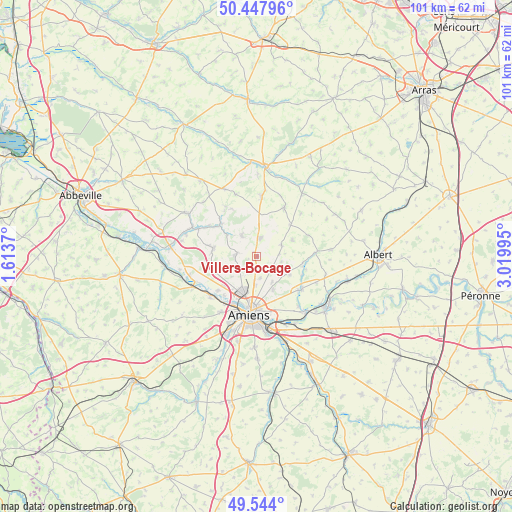
Villers-Bocage GPS coordinates[2]
49° 59' 53.16" North, 2° 19' 0.588" East
| Map corner | latitude | longitude |
|---|---|---|
| Upper-left | 50.44796°, | 1.6137° |
| Center: | 49.9981°, | 2.31683° |
| Lower-right: | 49.544°, | 3.01995° |
| Map W x H: | 100.5×100.5 km | = 62.4×62.4mi |
| max Lat: | 51.07786° ⇑6.4% North |
| Villers-Bocage: | 49.9981° |
| min Lat: | ⇓93.6% South 41.3874° |
| min Long | Villers-Bocage | max Long |
| -5.08615° | 2.31683° | 9.52242° |
| W 47.6%⇐ | ⇒52.4% E |
Elevation
Elevation of Villers-Bocage is 129 m = 423 ft, and this is 64.7 m = 212 ft below average elevation for this country.
| Max E: |
2333 m = 7654 ft | 50.9% |
| Avg. | 193.7 m = 635 ft | |
| Villers-Bocage | 129 m = 423 ft | |
Min E: |
-1 m = -3 ft | 49.1% |
See also: France elevation on elevation.city.
Geographical zone
Villers-Bocage is located in North temperate zone (between Tropic of Cancer and the Arctic Circle). Distance of this North polar circle is 1841.9 km =1144.5 mi to North.| Distance of | km | miles | from Villers-Bocage |
|---|---|---|---|
| North Pole | 4447.8 | 2763.7 | to North |
| Arctic Circle | 1841.9 | 1144.5 | to North |
| Tropic Cancer | 2953.3 | 1835.1 | to South |
| Equator | 5559.3 | 3454.4 | to South |


Nearby cities:
15 places around Villers-Bocage: (largest is in red/bold)
• Allonville
7.2 km =4.5 mi,  152°
152°
• Argoeuves
9.9 km =6.2 mi,  220°
220°
• Bertangles
3.4 km =2.1 mi,  202°
202°
• Canaples
9.5 km =5.9 mi,  312°
312°
• Flesselles
4 km =2.5 mi,  276°
276°
• Hérissart
7.8 km =4.8 mi,  65°
65°
• Naours
5.2 km =3.2 mi,  326°
326°
• Poulainville
5.6 km =3.5 mi,  182°
182°
• Querrieu
10.5 km =6.5 mi,  129°
129°
• Rainneville
3.9 km =2.4 mi, 134°
• Rubempré
5.4 km =3.4 mi, 65°
• Saint-Sauveur
10.1 km =6.3 mi,  228°
228°
• Saint-Vaast-en-Chaussée
9.1 km =5.7 mi,  247°
247°
• Talmas
3.7 km =2.3 mi,  9°
9°
• Vignacourt
8.7 km =5.4 mi, 280°
Sources, notices
• [Note1] Compared only with cities in France existing in our database
• [Src1] Map data: © OpenStreetMap contributors (CC-BY-SA)
• [Src2] Other city data from geonames.org with taken over terms of usage.
• [Src3] Geographical zone / Annual Mean Temperature by Robert A. Rohde @ Wikipedia
