Villeneuve-Tolosane geodata
Villeneuve-Tolosane (Occitanie) is a populated place; located in France in Europe/Paris (GMT+2) time zone. With population of 9,258 people, there are 1035 cities with bigger population in this country. Compared to other cities in France, 92.8% of cities are located further ↑North; 65.1% of cities are located further →East and 60.7% of cities have lower elevation than Villeneuve-Tolosane. Note1
Administrative division(s):
- Level 1: Occitanie
- Level 2: Haute-Garonne
- Level 3: Arrondissement de Toulouse
- Level 4: Villeneuve-Tolosane


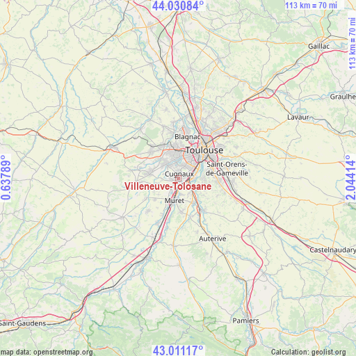
Villeneuve-Tolosane GPS coordinates[2]
43° 31' 23.376" North, 1° 20' 27.672" East
| Map corner | latitude | longitude |
|---|---|---|
| Upper-left | 44.03084°, | 0.63789° |
| Center: | 43.52316°, | 1.34102° |
| Lower-right: | 43.01117°, | 2.04414° |
| Map W x H: | 113.4×113.4 km | = 70.5×70.5mi |
| max Lat: | 51.07786° ⇑92.8% North |
| Villeneuve-Tolosane: | 43.52316° |
| min Lat: | ⇓7.2% South 41.3874° |
| min Long | Villeneuve-Tolo | max Long |
| -5.08615° | 1.34102° | 9.52242° |
| W 34.9%⇐ | ⇒65.1% E |
Elevation
Elevation of Villeneuve-Tolosane is 173 m = 568 ft, and this is 20.7 m = 68 ft below average elevation for this country.
| Max E: |
2333 m = 7654 ft | 39.3% |
| Avg. | 193.7 m = 635 ft | |
| Villeneuve-Tolosane | 173 m = 568 ft | |
Min E: |
-1 m = -3 ft | 60.7% |
See also: France elevation on elevation.city.
Geographical zone
Villeneuve-Tolosane is located in North temperate zone (between Tropic of Cancer and the Arctic Circle). Distance of this Northern Tropic circle is 2233.4 km =1387.8 mi to South.| Distance of | km | miles | from Villeneuve-Tolosane |
|---|---|---|---|
| North Pole | 5167.7 | 3211.1 | to North |
| Arctic Circle | 2561.9 | 1591.9 | to North |
| Tropic Cancer | 2233.4 | 1387.8 | to South |
| Equator | 4839.3 | 3007 | to South |


Nearby cities:
15 places around Villeneuve-Tolosane: (largest is in red/bold)
• Cugnaux
1.5 km =0.9 mi,  10°
10°
• Frouzins
1.6 km =1 mi,  233°
233°
• Goyrans
8.5 km =5.3 mi,  121°
121°
• La Salvetat-Saint-Gilles
8.1 km =5 mi,  316°
316°
• Lacroix-Falgarde
6.1 km =3.8 mi, 115°
• Lamasquère
8.9 km =5.5 mi,  239°
239°
• Muret
7.1 km =4.4 mi,  190°
190°
• Pinsaguel
4.1 km =2.5 mi,  110°
110°
• Plaisance-du-Touch
5.9 km =3.7 mi, 323°
• Portet-sur-Garonne
5.3 km =3.3 mi,  89°
89°
• Roquettes
3.6 km =2.2 mi,  142°
142°
• Saubens
4.9 km =3 mi,  169°
169°
• Seysses
3.7 km =2.3 mi,  221°
221°
• Tournefeuille
7.5 km =4.7 mi,  346°
346°
• Vieille-Toulouse
8.2 km =5.1 mi, 89°
Sources, notices
• [Note1] Compared only with cities in France existing in our database
• [Src1] Map data: © OpenStreetMap contributors (CC-BY-SA)
• [Src2] Other city data from geonames.org with taken over terms of usage.
• [Src3] Geographical zone / Annual Mean Temperature by Robert A. Rohde @ Wikipedia
