Frouzins geodata
Frouzins (Occitanie) is a populated place; located in France in Europe/Paris (GMT+2) time zone. With population of 6,418 people, there are 1542 cities with bigger population in this country. Compared to other cities in France, 92.9% of cities are located further ↑North; 65.3% of cities are located further →East and 61.3% of cities have lower elevation than Frouzins. Note1
Administrative division(s):
- Level 1: Occitanie
- Level 2: Haute-Garonne
- Level 3: Arrondissement de Muret
- Level 4: Frouzins


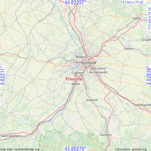
Frouzins GPS coordinates[2]
43° 30' 53.352" North, 1° 19' 30.828" East
| Map corner | latitude | longitude |
|---|---|---|
| Upper-left | 44.02257°, | 0.62211° |
| Center: | 43.51482°, | 1.32523° |
| Lower-right: | 43.00276°, | 2.02836° |
| Map W x H: | 113.4×113.4 km | = 70.5×70.5mi |
| max Lat: | 51.07786° ⇑92.9% North |
| Frouzins: | 43.51482° |
| min Lat: | ⇓7.1% South 41.3874° |
| min Long | Frouzins | max Long |
| -5.08615° | 1.32523° | 9.52242° |
| W 34.7%⇐ | ⇒65.3% E |
Elevation
Elevation of Frouzins is 176 m = 577 ft, and this is 17.7 m = 58 ft below average elevation for this country.
| Max E: |
2333 m = 7654 ft | 38.7% |
| Avg. | 193.7 m = 635 ft | |
| Frouzins | 176 m = 577 ft | |
Min E: |
-1 m = -3 ft | 61.3% |
See also: France elevation on elevation.city.
Geographical zone
Frouzins is located in North temperate zone (between Tropic of Cancer and the Arctic Circle). Distance of this Northern Tropic circle is 2232.5 km =1387.2 mi to South.| Distance of | km | miles | from Frouzins |
|---|---|---|---|
| North Pole | 5168.7 | 3211.7 | to North |
| Arctic Circle | 2562.8 | 1592.4 | to North |
| Tropic Cancer | 2232.5 | 1387.2 | to South |
| Equator | 4838.4 | 3006.4 | to South |


Nearby cities:
15 places around Frouzins: (largest is in red/bold)
• Cugnaux
2.8 km =1.7 mi,  32°
32°
• Fonsorbes
8.1 km =5 mi,  286°
286°
• La Salvetat-Saint-Gilles
8.1 km =5 mi,  327°
327°
• Labastidette
8.9 km =5.5 mi,  226°
226°
• Lacroix-Falgarde
7 km =4.3 mi,  103°
103°
• Lamasquère
7.3 km =4.5 mi,  240°
240°
• Muret
6.1 km =3.8 mi,  179°
179°
• Pinsaguel
5.1 km =3.2 mi, 95°
• Plaisance-du-Touch
6.1 km =3.8 mi,  338°
338°
• Portet-sur-Garonne
6.6 km =4.1 mi,  81°
81°
• Roquettes
4 km =2.5 mi,  119°
119°
• Saubens
4.4 km =2.7 mi,  151°
151°
• Seysses
2.2 km =1.4 mi,  211°
211°
• Tournefeuille
8.2 km =5.1 mi,  356°
356°
• Villeneuve-Tolosane
1.6 km =1 mi,  53°
53°
Sources, notices
• [Note1] Compared only with cities in France existing in our database
• [Src1] Map data: © OpenStreetMap contributors (CC-BY-SA)
• [Src2] Other city data from geonames.org with taken over terms of usage.
• [Src3] Geographical zone / Annual Mean Temperature by Robert A. Rohde @ Wikipedia
