Lacroix-Falgarde geodata
Lacroix-Falgarde (Occitanie) is a populated place; located in France in Europe/Paris (GMT+2) time zone. With population of 1,678 people, there are 5584 cities with bigger population in this country. Compared to other cities in France, 93.1% of cities are located further ↑North; 64.1% of cities are located further →East and 56.8% of cities have lower elevation than Lacroix-Falgarde. Note1
Administrative division(s):
- Level 1: Occitanie
- Level 2: Haute-Garonne
- Level 3: Arrondissement de Toulouse
- Level 4: Lacroix-Falgarde


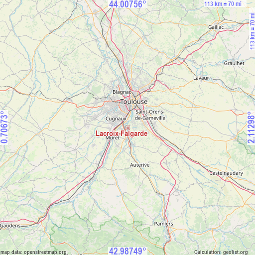
Lacroix-Falgarde GPS coordinates[2]
43° 29' 58.848" North, 1° 24' 35.46" East
| Map corner | latitude | longitude |
|---|---|---|
| Upper-left | 44.00756°, | 0.70673° |
| Center: | 43.49968°, | 1.40985° |
| Lower-right: | 42.98749°, | 2.11298° |
| Map W x H: | 113.4×113.4 km | = 70.5×70.5mi |
| max Lat: | 51.07786° ⇑93.1% North |
| Lacroix-Falgarde: | 43.49968° |
| min Lat: | ⇓6.9% South 41.3874° |
| min Long | Lacroix-Falgard | max Long |
| -5.08615° | 1.40985° | 9.52242° |
| W 35.9%⇐ | ⇒64.1% E |
Elevation
Elevation of Lacroix-Falgarde is 157 m = 515 ft, and this is 36.7 m = 120 ft below average elevation for this country.
| Max E: |
2333 m = 7654 ft | 43.2% |
| Avg. | 193.7 m = 635 ft | |
| Lacroix-Falgarde | 157 m = 515 ft | |
Min E: |
-1 m = -3 ft | 56.8% |
See also: France elevation on elevation.city.
Geographical zone
Lacroix-Falgarde is located in North temperate zone (between Tropic of Cancer and the Arctic Circle). Distance of this Northern Tropic circle is 2230.8 km =1386.2 mi to South.| Distance of | km | miles | from Lacroix-Falgarde |
|---|---|---|---|
| North Pole | 5170.4 | 3212.7 | to North |
| Arctic Circle | 2564.5 | 1593.5 | to North |
| Tropic Cancer | 2230.8 | 1386.2 | to South |
| Equator | 4836.7 | 3005.4 | to South |


Nearby cities:
15 places around Lacroix-Falgarde: (largest is in red/bold)
• Aureville
4 km =2.5 mi,  120°
120°
• Auzeville-Tolosane
6.6 km =4.1 mi,  61°
61°
• Clermont-le-Fort
5 km =3.1 mi,  170°
170°
• Cugnaux
6.7 km =4.2 mi,  307°
307°
• Frouzins
7 km =4.3 mi,  283°
283°
• Goyrans
2.5 km =1.6 mi,  138°
138°
• Labarthe-sur-Lèze
5.4 km =3.4 mi,  188°
188°
• Pechbusque
5 km =3.1 mi,  48°
48°
• Pinsaguel
2.1 km =1.3 mi,  304°
304°
• Portet-sur-Garonne
2.6 km =1.6 mi,  354°
354°
• Roquettes
3.3 km =2.1 mi,  265°
265°
• Saubens
5.2 km =3.2 mi,  244°
244°
• Vieille-Toulouse
3.7 km =2.3 mi,  44°
44°
• Vigoulet-Auzil
4.1 km =2.5 mi,  78°
78°
• Villeneuve-Tolosane
6.1 km =3.8 mi, 295°
Sources, notices
• [Note1] Compared only with cities in France existing in our database
• [Src1] Map data: © OpenStreetMap contributors (CC-BY-SA)
• [Src2] Other city data from geonames.org with taken over terms of usage.
• [Src3] Geographical zone / Annual Mean Temperature by Robert A. Rohde @ Wikipedia
