Seysses geodata
Seysses (Occitanie) is a populated place; located in France in Europe/Paris (GMT+2) time zone. With population of 6,466 people, there are 1527 cities with bigger population in this country. Compared to other cities in France, 93.1% of cities are located further ↑North; 65.4% of cities are located further →East and 61.9% of cities have lower elevation than Seysses. Note1
Administrative division(s):
- Level 1: Occitanie
- Level 2: Haute-Garonne
- Level 3: Arrondissement de Muret
- Level 4: Seysses


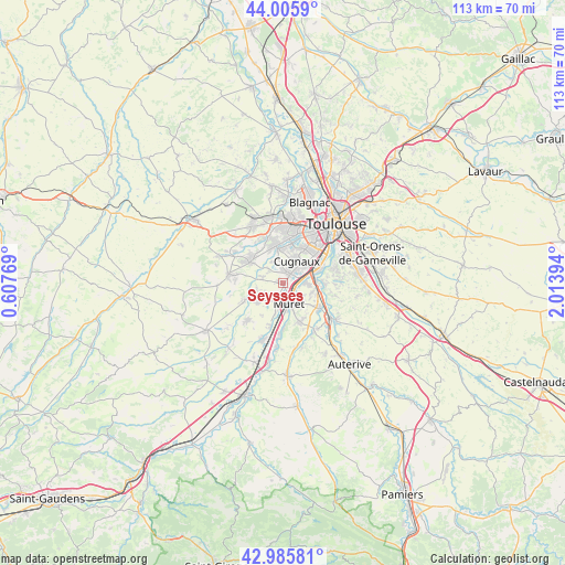
Seysses GPS coordinates[2]
43° 29' 52.836" North, 1° 18' 38.916" East
| Map corner | latitude | longitude |
|---|---|---|
| Upper-left | 44.0059°, | 0.60769° |
| Center: | 43.49801°, | 1.31081° |
| Lower-right: | 42.98581°, | 2.01394° |
| Map W x H: | 113.4×113.4 km | = 70.5×70.5mi |
| max Lat: | 51.07786° ⇑93.1% North |
| Seysses: | 43.49801° |
| min Lat: | ⇓6.9% South 41.3874° |
| min Long | Seysses | max Long |
| -5.08615° | 1.31081° | 9.52242° |
| W 34.6%⇐ | ⇒65.4% E |
Elevation
Elevation of Seysses is 179 m = 587 ft, and this is 14.7 m = 48 ft below average elevation for this country.
| Max E: |
2333 m = 7654 ft | 38.1% |
| Avg. | 193.7 m = 635 ft | |
| Seysses | 179 m = 587 ft | |
Min E: |
-1 m = -3 ft | 61.9% |
See also: France elevation on elevation.city.
Geographical zone
Seysses is located in North temperate zone (between Tropic of Cancer and the Arctic Circle). Distance of this Northern Tropic circle is 2230.6 km =1386 mi to South.| Distance of | km | miles | from Seysses |
|---|---|---|---|
| North Pole | 5170.5 | 3212.8 | to North |
| Arctic Circle | 2564.6 | 1593.6 | to North |
| Tropic Cancer | 2230.6 | 1386 | to South |
| Equator | 4836.5 | 3005.3 | to South |


Nearby cities:
15 places around Seysses: (largest is in red/bold)
• Cugnaux
5 km =3.1 mi,  32°
32°
• Fonsorbes
7.8 km =4.8 mi,  302°
302°
• Frouzins
2.2 km =1.4 mi, 31°
• Labarthe-sur-Lèze
8.8 km =5.5 mi,  125°
125°
• Labastidette
6.8 km =4.2 mi,  231°
231°
• Lacroix-Falgarde
8 km =5 mi,  88°
88°
• Lamasquère
5.5 km =3.4 mi,  251°
251°
• Muret
4.4 km =2.7 mi,  164°
164°
• Pinsaguel
6.4 km =4 mi,  77°
77°
• Plaisance-du-Touch
7.6 km =4.7 mi,  351°
351°
• Portet-sur-Garonne
8.2 km =5.1 mi,  69°
69°
• Roquettes
4.7 km =2.9 mi, 90°
• Saint-Clar-de-Rivière
8.5 km =5.3 mi,  244°
244°
• Saubens
3.9 km =2.4 mi,  121°
121°
• Villeneuve-Tolosane
3.7 km =2.3 mi,  41°
41°
Sources, notices
• [Note1] Compared only with cities in France existing in our database
• [Src1] Map data: © OpenStreetMap contributors (CC-BY-SA)
• [Src2] Other city data from geonames.org with taken over terms of usage.
• [Src3] Geographical zone / Annual Mean Temperature by Robert A. Rohde @ Wikipedia
