Pinsaguel geodata
Pinsaguel (Occitanie) is a populated place; located in France in Europe/Paris (GMT+2) time zone. With population of 2,609 people, there are 3740 cities with bigger population in this country. Compared to other cities in France, 92.9% of cities are located further ↑North; 64.4% of cities are located further →East and 56.1% of cities have lower elevation than Pinsaguel. Note1
Administrative division(s):
- Level 1: Occitanie
- Level 2: Haute-Garonne
- Level 3: Arrondissement de Muret
- Level 4: Pinsaguel


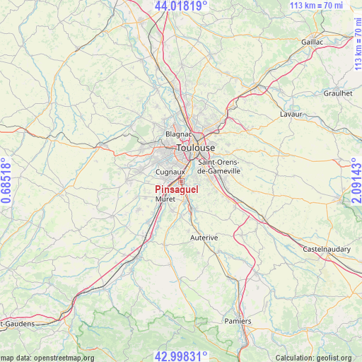
Pinsaguel GPS coordinates[2]
43° 30' 37.44" North, 1° 23' 17.916" East
| Map corner | latitude | longitude |
|---|---|---|
| Upper-left | 44.01819°, | 0.68518° |
| Center: | 43.5104°, | 1.38831° |
| Lower-right: | 42.99831°, | 2.09143° |
| Map W x H: | 113.4×113.4 km | = 70.5×70.5mi |
| max Lat: | 51.07786° ⇑92.9% North |
| Pinsaguel: | 43.5104° |
| min Lat: | ⇓7.1% South 41.3874° |
| min Long | Pinsaguel | max Long |
| -5.08615° | 1.38831° | 9.52242° |
| W 35.6%⇐ | ⇒64.4% E |
Elevation
Elevation of Pinsaguel is 154 m = 505 ft, and this is 39.7 m = 130 ft below average elevation for this country.
| Max E: |
2333 m = 7654 ft | 43.9% |
| Avg. | 193.7 m = 635 ft | |
| Pinsaguel | 154 m = 505 ft | |
Min E: |
-1 m = -3 ft | 56.1% |
See also: France elevation on elevation.city.
Geographical zone
Pinsaguel is located in North temperate zone (between Tropic of Cancer and the Arctic Circle). Distance of this Northern Tropic circle is 2232 km =1386.9 mi to South.| Distance of | km | miles | from Pinsaguel |
|---|---|---|---|
| North Pole | 5169.2 | 3212 | to North |
| Arctic Circle | 2563.3 | 1592.8 | to North |
| Tropic Cancer | 2232 | 1386.9 | to South |
| Equator | 4837.9 | 3006.1 | to South |


Nearby cities:
15 places around Pinsaguel: (largest is in red/bold)
• Aureville
6.1 km =3.8 mi,  122°
122°
• Clermont-le-Fort
6.6 km =4.1 mi,  157°
157°
• Cugnaux
4.6 km =2.9 mi,  309°
309°
• Frouzins
5.1 km =3.2 mi,  275°
275°
• Goyrans
4.6 km =2.9 mi,  132°
132°
• Labarthe-sur-Lèze
6.6 km =4.1 mi,  171°
171°
• Lacroix-Falgarde
2.1 km =1.3 mi, 124°
• Pechbusque
5.9 km =3.7 mi,  68°
68°
• Portet-sur-Garonne
2.1 km =1.3 mi,  45°
45°
• Roquettes
2.2 km =1.4 mi,  227°
227°
• Saubens
4.5 km =2.8 mi,  220°
220°
• Seysses
6.4 km =4 mi,  257°
257°
• Vieille-Toulouse
4.6 km =2.9 mi, 71°
• Vigoulet-Auzil
5.8 km =3.6 mi,  93°
93°
• Villeneuve-Tolosane
4.1 km =2.5 mi,  290°
290°
Sources, notices
• [Note1] Compared only with cities in France existing in our database
• [Src1] Map data: © OpenStreetMap contributors (CC-BY-SA)
• [Src2] Other city data from geonames.org with taken over terms of usage.
• [Src3] Geographical zone / Annual Mean Temperature by Robert A. Rohde @ Wikipedia
