Portet-sur-Garonne geodata
Portet-sur-Garonne (Occitanie) is a populated place; located in France in Europe/Paris (GMT+2) time zone. With population of 9,794 people, there are 972 cities with bigger population in this country. Compared to other cities in France, 92.8% of cities are located further ↑North; 64.2% of cities are located further →East and 55.9% of cities have lower elevation than Portet-sur-Garonne. Note1
Administrative division(s):
- Level 1: Occitanie
- Level 2: Haute-Garonne
- Level 3: Arrondissement de Muret
- Level 4: Portet-sur-Garonne


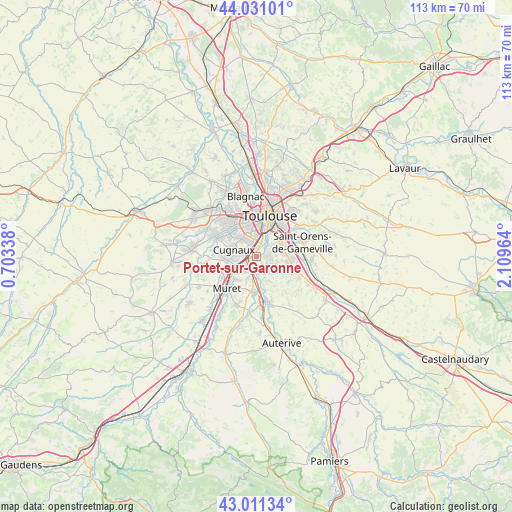
Portet-sur-Garonne GPS coordinates[2]
43° 31' 23.988" North, 1° 24' 23.436" East
| Map corner | latitude | longitude |
|---|---|---|
| Upper-left | 44.03101°, | 0.70338° |
| Center: | 43.52333°, | 1.40651° |
| Lower-right: | 43.01134°, | 2.10964° |
| Map W x H: | 113.4×113.4 km | = 70.5×70.5mi |
| max Lat: | 51.07786° ⇑92.8% North |
| Portet-sur-Garonne: | 43.52333° |
| min Lat: | ⇓7.2% South 41.3874° |
| min Long | Portet-sur-Garo | max Long |
| -5.08615° | 1.40651° | 9.52242° |
| W 35.8%⇐ | ⇒64.2% E |
Elevation
Elevation of Portet-sur-Garonne is 153 m = 502 ft, and this is 40.7 m = 134 ft below average elevation for this country.
| Max E: |
2333 m = 7654 ft | 44.1% |
| Avg. | 193.7 m = 635 ft | |
| Portet-sur-Garonne | 153 m = 502 ft | |
Min E: |
-1 m = -3 ft | 55.9% |
See also: France elevation on elevation.city.
Geographical zone
Portet-sur-Garonne is located in North temperate zone (between Tropic of Cancer and the Arctic Circle). Distance of this Northern Tropic circle is 2233.4 km =1387.8 mi to South.| Distance of | km | miles | from Portet-sur-Garonne |
|---|---|---|---|
| North Pole | 5167.7 | 3211.1 | to North |
| Arctic Circle | 2561.8 | 1591.8 | to North |
| Tropic Cancer | 2233.4 | 1387.8 | to South |
| Equator | 4839.3 | 3007 | to South |


Nearby cities:
15 places around Portet-sur-Garonne: (largest is in red/bold)
• Aureville
5.9 km =3.7 mi,  141°
141°
• Auzeville-Tolosane
6.1 km =3.8 mi,  85°
85°
• Castanet-Tolosan
7.5 km =4.7 mi,  96°
96°
• Cugnaux
5.2 km =3.2 mi,  286°
286°
• Frouzins
6.6 km =4.1 mi,  261°
261°
• Goyrans
4.9 km =3 mi,  156°
156°
• Lacroix-Falgarde
2.6 km =1.6 mi,  174°
174°
• Pechbusque
4.1 km =2.5 mi,  80°
80°
• Pinsaguel
2.1 km =1.3 mi,  225°
225°
• Ramonville-Saint-Agne
6.1 km =3.8 mi,  65°
65°
• Roquettes
4.2 km =2.6 mi, 226°
• Saubens
6.5 km =4 mi,  222°
222°
• Vieille-Toulouse
2.9 km =1.8 mi, 89°
• Vigoulet-Auzil
4.7 km =2.9 mi,  112°
112°
• Villeneuve-Tolosane
5.3 km =3.3 mi,  269°
269°
Sources, notices
• [Note1] Compared only with cities in France existing in our database
• [Src1] Map data: © OpenStreetMap contributors (CC-BY-SA)
• [Src2] Other city data from geonames.org with taken over terms of usage.
• [Src3] Geographical zone / Annual Mean Temperature by Robert A. Rohde @ Wikipedia
