Chamant geodata
Chamant (Hauts-de-France) is a populated place; located in France in Europe/Paris (GMT+2) time zone. With population of 1,023 people, there are 8668 cities with bigger population in this country. Compared to other cities in France, 84.6% of cities are located further ↓South; 52.2% of cities are located further ←West and 71.9% of cities have higher elevation than Chamant. Note1
Administrative division(s):
- Level 1: Hauts-de-France
- Level 2: Département de l'Oise
- Level 3: Arrondissement de Senlis
- Level 4: Chamant


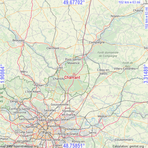
Chamant GPS coordinates[2]
49° 13' 11.64" North, 2° 36' 42.336" East
| Map corner | latitude | longitude |
|---|---|---|
| Upper-left | 49.67702°, | 1.90864° |
| Center: | 49.2199°, | 2.61176° |
| Lower-right: | 48.75851°, | 3.31489° |
| Map W x H: | 102.1×102.1 km | = 63.4×63.4mi |
| max Lat: | 51.07786° ⇑15.4% North |
| Chamant: | 49.2199° |
| min Lat: | ⇓84.6% South 41.3874° |
| min Long | Chamant | max Long |
| -5.08615° | 2.61176° | 9.52242° |
| W 52.2%⇐ | ⇒47.8% E |
Elevation
Elevation of Chamant is 74 m = 243 ft, and this is 119.7 m = 393 ft below average elevation for this country.
| Max E: |
2333 m = 7654 ft | 71.9% |
| Avg. | 193.7 m = 635 ft | |
| Chamant | 74 m = 243 ft | |
Min E: |
-1 m = -3 ft | 28.1% |
See also: France elevation on elevation.city.
Geographical zone
Chamant is located in North temperate zone (between Tropic of Cancer and the Arctic Circle). Distance of this North polar circle is 1928.4 km =1198.3 mi to North.| Distance of | km | miles | from Chamant |
|---|---|---|---|
| North Pole | 4534.3 | 2817.5 | to North |
| Arctic Circle | 1928.4 | 1198.3 | to North |
| Tropic Cancer | 2866.8 | 1781.3 | to South |
| Equator | 5472.7 | 3400.6 | to South |


Nearby cities:
15 places around Chamant: (largest is in red/bold)
• Apremont
7.5 km =4.7 mi,  273°
273°
• Aumont-en-Halatte
4.7 km =2.9 mi,  288°
288°
• Avilly-Saint-Léonard
5.8 km =3.6 mi,  241°
241°
• Barbery
4.1 km =2.5 mi,  86°
86°
• Courteuil
6.1 km =3.8 mi,  248°
248°
• Fleurines
4.8 km =3 mi,  335°
335°
• Pont-Sainte-Maxence
9.1 km =5.7 mi,  356°
356°
• Pontarmé
8.6 km =5.3 mi,  211°
211°
• Rully
8.6 km =5.3 mi,  78°
78°
• Senlis
2.3 km =1.4 mi,  232°
232°
• Thiers-sur-Thève
8.1 km =5 mi,  201°
201°
• Verneuil-en-Halatte
9.2 km =5.7 mi,  315°
315°
• Villeneuve-sur-Verberie
8.3 km =5.2 mi,  42°
42°
• Villers-Saint-Frambourg
4.4 km =2.7 mi,  27°
27°
• Vineuil-Saint-Firmin
8.7 km =5.4 mi,  255°
255°
Sources, notices
• [Note1] Compared only with cities in France existing in our database
• [Src1] Map data: © OpenStreetMap contributors (CC-BY-SA)
• [Src2] Other city data from geonames.org with taken over terms of usage.
• [Src3] Geographical zone / Annual Mean Temperature by Robert A. Rohde @ Wikipedia
