Villar-Saint-Pancrace geodata
Villar-Saint-Pancrace (Provence-Alpes-Côte d'Azur) is a populated place; located in France in Europe/Paris (GMT+2) time zone. With population of 1,528 people, there are 6091 cities with bigger population in this country. Compared to other cities in France, 80.7% of cities are located further ↑North; 92.5% of cities are located further ←West and 99.7% of cities have lower elevation than Villar-Saint-Pancrace. Note1
Administrative division(s):
- Level 1: Provence-Alpes-Côte d'Azur
- Level 2: Hautes-Alpes
- Level 3: Arrondissement de Briançon
- Level 4: Villar-Saint-Pancrace
Current local time in Villar-Saint-Pancrace:
05:51 AM, WednesdayDifference from your time zone: hours


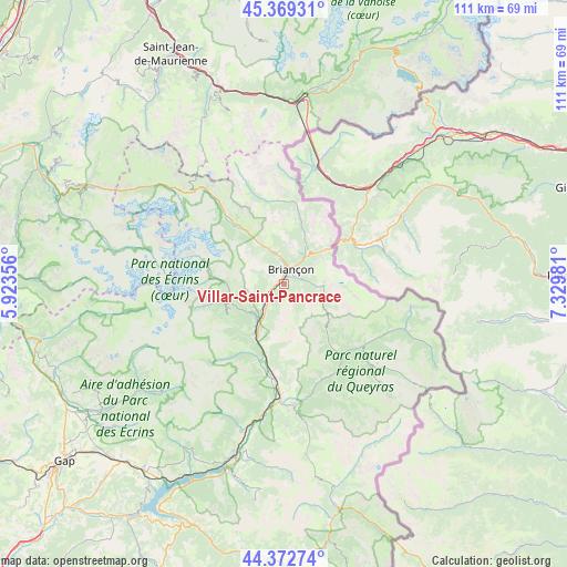
Villar-Saint-Pancrace GPS coordinates[2]
44° 52' 23.448" North, 6° 37' 36.084" East
| Map corner | latitude | longitude |
|---|---|---|
| Upper-left | 45.36931°, | 5.92356° |
| Center: | 44.87318°, | 6.62669° |
| Lower-right: | 44.37274°, | 7.32981° |
| Map W x H: | 110.8×110.8 km | = 68.8×68.8mi |
| max Lat: | 51.07786° ⇑80.7% North |
| Villar-Saint-Pancrace: | 44.87318° |
| min Lat: | ⇓19.3% South 41.3874° |
| min Long | Villar-Saint-Pa | max Long |
| -5.08615° | 6.62669° | 9.52242° |
| W 92.5%⇐ | ⇒7.5% E |
Elevation
Elevation of Villar-Saint-Pancrace is 1236 m = 4055 ft, and this is 1042.3 m = 3420 ft above average elevation for this country.
| Max E: |
2333 m = 7654 ft | 0.3% |
| Villar-Saint-Pancrace | 1236 m 4055 ft | |
| Avg. | 193.7 m = 635 ft | |
Min E: |
-1 m = -3 ft | 99.7% |
See also: France elevation on elevation.city.
Geographical zone
Villar-Saint-Pancrace is located in North temperate zone (between Tropic of Cancer and the Arctic Circle). Distance of this Northern Tropic circle is 2383.5 km =1481 mi to South.| Distance of | km | miles | from Villar-Saint-Pancrace |
|---|---|---|---|
| North Pole | 5017.6 | 3117.8 | to North |
| Arctic Circle | 2411.7 | 1498.6 | to North |
| Tropic Cancer | 2383.5 | 1481 | to South |
| Equator | 4989.4 | 3100.3 | to South |


Nearby cities:
15 places around Villar-Saint-Pancrace: (largest is in red/bold)
• Briançon
3.2 km =2 mi,  22°
22°
• Châteauroux-les-Alpes
29.9 km =18.6 mi,  196°
196°
• Guillestre
23.8 km =14.8 mi,  175°
175°
• La Roche-de-Rame
14.2 km =8.8 mi, 195°
• Le Monêtier-les-Bains
14.7 km =9.1 mi,  320°
320°
• Montgenèvre
9.9 km =6.2 mi,  48°
48°
• Orcières
31.7 km =19.7 mi,  228°
228°
• Risoul
25 km =15.5 mi, 177°
• Saint-Chaffrey
6 km =3.7 mi,  345°
345°
• Saint-Crépin
18.6 km =11.6 mi, 184°
• Saint-Martin-de-Queyrières
6.7 km =4.2 mi,  214°
214°
• Val-des-Prés
9.4 km =5.8 mi,  25°
25°
• Vallouise
11.3 km =7 mi,  254°
254°
• Vars
31.1 km =19.3 mi,  170°
170°
• Villeneuve
9.3 km =5.8 mi,  328°
328°
Sources, notices
• [Note1] Compared only with cities in France existing in our database
• [Src1] Map data: © OpenStreetMap contributors (CC-BY-SA)
• [Src2] Other city data from geonames.org with taken over terms of usage.
• [Src3] Geographical zone / Annual Mean Temperature by Robert A. Rohde @ Wikipedia
