Saint-Crépin geodata
Saint-Crépin (Provence-Alpes-Côte d'Azur) is a populated place; located in France in Europe/Paris (GMT+2) time zone. With population of 576 people, there are 13727 cities with bigger population in this country. Compared to other cities in France, 82.1% of cities are located further ↑North; 92.4% of cities are located further ←West and 98.9% of cities have lower elevation than Saint-Crépin. Note1
Administrative division(s):
- Level 1: Provence-Alpes-Côte d'Azur
- Level 2: Hautes-Alpes
- Level 3: Arrondissement de Briançon
- Level 4: Saint-Crépin


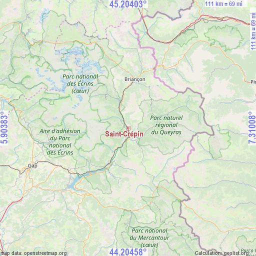
Saint-Crépin GPS coordinates[2]
44° 42' 23.256" North, 6° 36' 25.02" East
| Map corner | latitude | longitude |
|---|---|---|
| Upper-left | 45.20403°, | 5.90383° |
| Center: | 44.70646°, | 6.60695° |
| Lower-right: | 44.20458°, | 7.31008° |
| Map W x H: | 111.1×111.1 km | = 69×69mi |
| max Lat: | 51.07786° ⇑82.1% North |
| Saint-Crépin: | 44.70646° |
| min Lat: | ⇓17.9% South 41.3874° |
| min Long | Saint-Crépin | max Long |
| -5.08615° | 6.60695° | 9.52242° |
| W 92.4%⇐ | ⇒7.6% E |
Elevation
Elevation of Saint-Crépin is 939 m = 3081 ft, and this is 745.3 m = 2445 ft above average elevation for this country.
| Max E: |
2333 m = 7654 ft | 1.1% |
| Saint-Crépin | 939 m 3081 ft | |
| Avg. | 193.7 m = 635 ft | |
Min E: |
-1 m = -3 ft | 98.9% |
See also: France elevation on elevation.city.
Geographical zone
Saint-Crépin is located in North temperate zone (between Tropic of Cancer and the Arctic Circle). Distance of this Northern Tropic circle is 2365 km =1469.5 mi to South.| Distance of | km | miles | from Saint-Crépin |
|---|---|---|---|
| North Pole | 5036.2 | 3129.3 | to North |
| Arctic Circle | 2430.3 | 1510.1 | to North |
| Tropic Cancer | 2365 | 1469.5 | to South |
| Equator | 4970.9 | 3088.8 | to South |


Nearby cities:
15 places around Saint-Crépin: (largest is in red/bold)
• Briançon
21.7 km =13.5 mi,  7°
7°
• Châteauroux-les-Alpes
12.2 km =7.6 mi,  213°
213°
• Embrun
18.2 km =11.3 mi, 209°
• Guillestre
6.2 km =3.9 mi,  147°
147°
• La Roche-de-Rame
5.3 km =3.3 mi,  336°
336°
• Montgenèvre
26.6 km =16.5 mi,  19°
19°
• Orcières
22.4 km =13.9 mi,  263°
263°
• Risoul
7 km =4.3 mi,  158°
158°
• Saint-Chaffrey
24.4 km =15.2 mi,  0°
0°
• Saint-Martin-de-Queyrières
13.2 km =8.2 mi,  350°
350°
• Savines-le-Lac
25.6 km =15.9 mi,  218°
218°
• Vallouise
18.1 km =11.2 mi,  329°
329°
• Vars
13.8 km =8.6 mi, 151°
• Villar-Saint-Pancrace
18.6 km =11.6 mi, 4°
• Villeneuve
26.7 km =16.6 mi, 352°
Sources, notices
• [Note1] Compared only with cities in France existing in our database
• [Src1] Map data: © OpenStreetMap contributors (CC-BY-SA)
• [Src2] Other city data from geonames.org with taken over terms of usage.
• [Src3] Geographical zone / Annual Mean Temperature by Robert A. Rohde @ Wikipedia
